
Le Bourg topographic map
Interactive map
Click on the map to display elevation.
About this map
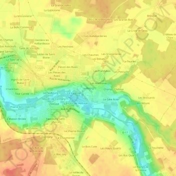
Name: Le Bourg topographic map, elevation, terrain.
Average elevation: 83 m
Minimum elevation: 53 m
Maximum elevation: 100 m
Other topographic maps
Click on a map to view its topography, its elevation and its terrain.
Charentais
France > Centre-Val de Loire > Indre-et-Loire > Truyes > Charentais
Charentais, Truyes, Tours, Indre-et-Loire, Centre-Val de Loire, France métropolitaine, 37320, France
Average elevation: 82 m
Sables de Saint-Blaise
France > Centre-Val de Loire > Indre-et-Loire > Truyes > Sables de Saint-Blaise
Sables de Saint-Blaise, Truyes, Tours, Indre-et-Loire, Centre-Val de Loire, France métropolitaine, 37320, France
Average elevation: 82 m