
Estación San Agustín ( La Placa ) topographic map
Interactive map
Click on the map to display elevation.
About this map
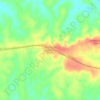
Name: Estación San Agustín ( La Placa ) topographic map, elevation, terrain.
Location: Estación San Agustín ( La Placa ), Palenque, Chiapas, México (17.51014 -91.77779 17.55014 -91.73779)
Average elevation: 47 m
Minimum elevation: 20 m
Maximum elevation: 79 m
Other topographic maps
Click on a map to view its topography, its elevation and its terrain.
Río Chancalá
Río Chancalá, Palenque, Chiapas, México
Average elevation: 196 m