
Thank you for supporting this site ❤️
Make a donation
Make a donation
Ebbw Vale topographic map
Click on the map to display elevation.
Thank you for supporting this site ❤️
Make a donation
Make a donation
About this map
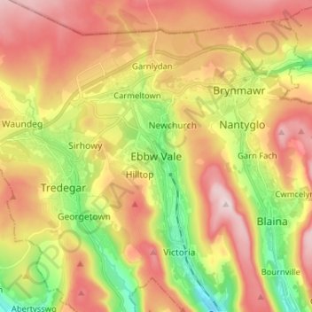
Name: Ebbw Vale topographic map, elevation, terrain.
Location: Ebbw Vale, Blaenau Gwent, Wales, NP23 6JQ, United Kingdom (51.74129 -3.24844 51.82129 -3.16844)
Average elevation: 384 m
Minimum elevation: 208 m
Maximum elevation: 550 m
Thank you for supporting this site ❤️
Make a donation
Make a donation
Other topographic maps
Click on a map to view its topography, its elevation and its terrain.