Umbria topographic map
Interactive map
Click on the map to display elevation.
About this map
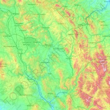
Name: Umbria topographic map, elevation, terrain.
Location: Umbria, Italy (42.36478 11.89203 43.61734 13.26419)
Average elevation: 521 m
Minimum elevation: 15 m
Maximum elevation: 2,445 m
Umbria is bordered by Tuscany to the west and the north, Marche to the east and Lazio to the south. Partly hilly and mountainous, and partly flat and fertile owing to the valley of the Tiber, its topography includes part of the central Apennines, with the highest point in the region at Monte Vettore on the border of the Marche, at 2,476 metres (8,123 feet); the lowest point is Attigliano, 96 metres (315 feet). It is the only Italian region having neither a coastline nor a common border with other countries. The comune of Città di Castello has an exclave named Monte Ruperto within Marche. Contained within Umbria is the hamlet of Cospaia, which was a tiny republic from 1440 to 1826, created by accident.
Other topographic maps
Click on a map to view its topography, its elevation and its terrain.
Parch Natural Pöz-Odles - Naturpark Puez-Geisler - Parco Naturale Puez-Odle
Italy > Trentino-Alto Adige/Südtirol > South Tyrol
Parch Natural Pöz-Odles - Naturpark Puez-Geisler - Parco Naturale Puez-Odle, South Tyrol, Trentino-Alto Adige/Südtirol, Italy
Average elevation: 1,882 m
Castelvetrano
Italy > Sicily > Castelvetrano
Castelvetrano, TP, Sicily, 91022, Italy
Average elevation: 124 m
Castelfidardo
Italy > Marche > Castelfidardo
Castelfidardo, AN, Marche, 60022, Italy
Average elevation: 52 m
Castel
Italy > Trentino-Alto Adige/Südtirol > Predazzo
Castel, Predazzo, Comunità territoriale della Val di Fiemme, TN, Trentino-Alto Adige/Südtirol, Italy
Average elevation: 2,005 m
Courmayeur
Italy > Aosta Valley > Courmayeur
Courmayeur, Aosta Valley, 11013, Italy
Average elevation: 2,367 m
Borgo Virgilio
Italy > Lombardy > Borgo Virgilio
Borgo Virgilio, Mantua, Lombardy, Italy
Average elevation: 20 m
Vittorio Veneto
Italy > Veneto > Vittorio Veneto
Vittorio Veneto, TV, Veneto, 31029, Italy
Average elevation: 525 m
Valtournenche
Italy > Aosta Valley > Valtournenche
Valtournenche, Aosta Valley, Italy
Average elevation: 2,640 m
Il Von
Italy > Friuli Venezia Giulia > Frisanco
Il Von, Frisanco, UTI delle Valli e delle Dolomiti Friulane, Friuli Venezia Giulia, Italy
Average elevation: 769 m
Sant'Ambrogio di Torino
Italy > Piemont > Sant'Ambrogio di Torino
Sant'Ambrogio di Torino, TO, Piemont, 10057, Italy
Average elevation: 481 m
Ronco Canavese
Italy > Piemont > Ronco Canavese
Ronco Canavese, TO, Piemont, Italy
Average elevation: 1,854 m
Peio
Italy > Trentino-Alto Adige/Südtirol > Peio
Peio, Comunità della Valle di Sole, TN, Trentino-Alto Adige/Südtirol, 38024, Italy
Average elevation: 2,345 m
Salorno - Salurn
Italy > Trentino-Alto Adige/Südtirol > Salorno - Salurn
Salorno - Salurn, Überetsch-Unterland - Oltradige-Bassa Atesina, South Tyrol, Trentino-Alto Adige/Südtirol, Italy
Average elevation: 774 m
Castel del Piano
Italy > Tuscany > Castel del Piano
Castel del Piano, Unione dei Comuni Montani Amiata Grossetana, GR, Tuscany, 58033, Italy
Average elevation: 561 m
San Biagio di Callalta
Italy > Veneto > San Biagio di Callalta
San Biagio di Callalta, TV, Veneto, Italy
Average elevation: 12 m
Municipio Roma IX
Municipio Roma IX, Rome, RM, Lazio, Italy
Average elevation: 81 m