
Hokkaido Prefecture topographic map
Interactive map
Click on the map to display elevation.
About this map
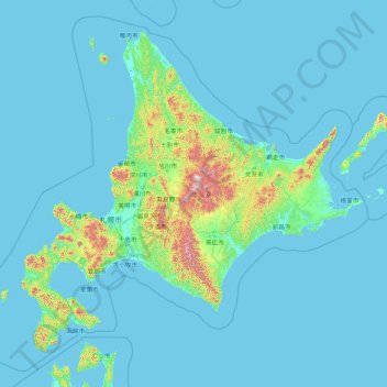
Name: Hokkaido Prefecture topographic map, elevation, terrain.
Location: Hokkaido Prefecture, Japan (41.15206 139.06728 45.71120 145.91603)
Average elevation: 81 m
Minimum elevation: -3 m
Maximum elevation: 2,072 m
As Japan's coldest region, Hokkaidō has relatively cool summers and icy/snowy winters. Most of the island falls in the humid continental climate zone with Köppen climate classification Dfb (hemiboreal) in most areas but Dfa (hot summer humid continental) in some inland lowlands. The average August temperature ranges from 17 to 22 °C (62.6 to 71.6 °F), while the average January temperature ranges from −12 to −4 °C (10.4 to 24.8 °F), in both cases depending on elevation and distance from the ocean, though temperatures on the western side of the island tend to be a little warmer than on the eastern. The highest temperature ever recorded is 39.5 °C (103.1 °F) on 26 May 2019.
Other topographic maps
Click on a map to view its topography, its elevation and its terrain.
Niseko
Niseko, Abuta County, Shiribeshi Subprefecture, Hokkaido Prefecture, Japan
Average elevation: 339 m
Kyoto
Japan > Kinki Region > Kyoto
Higashiyama Ward, Kyoto, Kyoto Prefecture, Kinki Region, Japan
Average elevation: 79 m
Hokkaido
Japan > Hokkaidō Region > Shintoku
Hokkaido, トノカリ2の沢支線林道, Shintoku, Kamikawa, Tokachi Subprefecture, Hokkaidō Prefecture, Hokkaidō Region, Japan
Average elevation: 826 m
Zentsuji
Zentsuji, Kagawa Prefecture, Shikoku Region, 765-0003, Japan
Average elevation: 84 m
山王
Japan > Ibaraki Prefecture > Toride > 山王
山王, Toride, Ibaraki Prefecture, Kanto, 300-1537, Japan
Average elevation: 9 m
Kadena
Kadena, Nakagami, Okinawa Prefecture, Kyushu Region, Japan
Average elevation: 49 m
Ashigarashimo District
Hakone, Ashigarashimo District, Kanagawa Prefecture, Kanto, Japan
Average elevation: 722 m
Shibetsu
Shibetsu, Nemuro Subprefecture, Hokkaidō Prefecture, Hokkaidō Region, 086-1632, Japan
Average elevation: 105 m
Nikkō
Japan > Tochigi Prefecture > Nikkō > Nikko
Nikkō, Nikko, Tochigi Prefecture, Kanto, 3211273, Japan
Average elevation: 564 m
湊入船町
Japan > Chubu Region > Toyama > 湊入船町
湊入船町, Toyama, Toyama Prefecture, Chubu Region, 930-0001, Japan
Average elevation: 13 m
Ryukyu Islands
Japan > Kyushu Region > Nago
Ryukyu Islands, Green Street, Nago, Okinawa Prefecture, Kyushu Region, 905-2266, Japan
Average elevation: 4 m
Mt. Tsurugi
Japan > Shikoku Region > Naka
Mt. Tsurugi, Naka, Naka County, Tokushima Prefecture, Shikoku Region, 779-4306, Japan
Average elevation: 1,584 m
Shikoku
Japan > Shikoku Region > Hidaka
Shikoku, Hidaka, Takaoka County, Kochi Prefecture, Shikoku Region, Japan
Average elevation: 156 m
Osaka
Japan > Kinki Region > Osaka
Kita, Osaka, Osaka Prefecture, Kinki Region, Japan
Average elevation: 10 m
Smith Island
Smith Island, Hachijō Subprefecture, Tokyo, Kanto, Japan
Average elevation: 0 m
辺野古岳
Japan > Kyushu Region > Nago
辺野古岳, Nago, Okinawa Prefecture, Kyushu Region, 905-0024, Japan
Average elevation: 143 m
Mooka
Mooka, Tochigi Prefecture, Kanto, 3214334, Japan
Average elevation: 78 m
Tsushima
Tsushima, Nagasaki Prefecture, Kyushu Region, Japan
Average elevation: 7 m
Honshu
Japan > Tohoku > Aizumisato
Honshu, Aizumisato, Onuma, Fukushima Prefecture, Tohoku, Japan
Average elevation: 91 m