
Söllereck topographic map
Interactive map
Click on the map to display elevation.
About this map
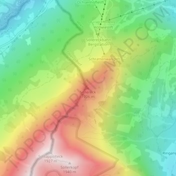
Name: Söllereck topographic map, elevation, terrain.
Average elevation: 1,339 m
Minimum elevation: 917 m
Maximum elevation: 1,916 m
Other topographic maps
Click on a map to view its topography, its elevation and its terrain.
Schochen
Deutschland > Bayern > Landkreis Oberallgäu > Oberstdorf
Schochen, Oberstdorf, Landkreis Oberallgäu, Bayern, Deutschland
Average elevation: 1,643 m
Linkerskopf
Deutschland > Bayern > Landkreis Oberallgäu > Oberstdorf
Linkerskopf, Oberstdorf, Landkreis Oberallgäu, Bayern, Deutschland
Average elevation: 1,995 m
Trettach
Deutschland > Bayern > Landkreis Oberallgäu > Oberstdorf
Trettach, Oberstdorf, Landkreis Oberallgäu, Bayern, Deutschland
Average elevation: 1,469 m
Schlappolt
Deutschland > Bayern > Landkreis Oberallgäu > Oberstdorf
Schlappolt, Laiter, Oberstdorf, Landkreis Oberallgäu, Bayern, 87561, Deutschland
Average elevation: 1,587 m
Tiefenbach
Deutschland > Bayern > Landkreis Oberallgäu > Oberstdorf > Tiefenbach
Tiefenbach, Oberstdorf, Landkreis Oberallgäu, Bayern, 87561, Deutschland
Average elevation: 971 m
Gottenried
Deutschland > Bayern > Landkreis Oberallgäu > Oberstdorf > Gottenried
Gottenried, Oberstdorf, Landkreis Oberallgäu, Bayern, Deutschland
Average elevation: 1,288 m
Stillachtal
Deutschland > Bayern > Landkreis Oberallgäu > Oberstdorf
Stillachtal, Oberstdorf, Landkreis Oberallgäu, Bayern, 87561, Deutschland
Average elevation: 1,363 m
Hirschegg
Deutschland > Bayern > Landkreis Oberallgäu > Oberstdorf
Hirschegg, Oberstdorf, Landkreis Oberallgäu, Bayern, Deutschland
Average elevation: 1,594 m
Kornau
Deutschland > Bayern > Landkreis Oberallgäu > Oberstdorf
Kornau, Oberstdorf, Landkreis Oberallgäu, Bayern, 87561, Deutschland
Average elevation: 964 m
Schöllang
Deutschland > Bayern > Landkreis Oberallgäu > Oberstdorf
Schöllang, Oberstdorf, Landkreis Oberallgäu, Bayern, 87538, Deutschland
Average elevation: 966 m
Musberg
Deutschland > Bayern > Landkreis Oberallgäu > Oberstdorf
Musberg, Oberstdorf, Landkreis Oberallgäu, Bayern, Deutschland
Average elevation: 1,375 m
Trettachspitze
Deutschland > Bayern > Landkreis Oberallgäu > Oberstdorf
Trettachspitze, Oberstdorf, Landkreis Oberallgäu, Bayern, Deutschland
Average elevation: 2,045 m
Hochfrottspitze
Deutschland > Bayern > Landkreis Oberallgäu > Oberstdorf
Hochfrottspitze, Oberstdorf, Landkreis Oberallgäu, Bayern, Deutschland
Average elevation: 2,109 m