
Les Anses-d'Arlet topographic map
Interactive map
Click on the map to display elevation.
About this map
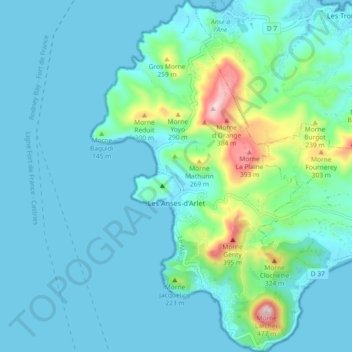
Name: Les Anses-d'Arlet topographic map, elevation, terrain.
Location: Les Anses-d'Arlet, Le Marin, Martinica, 97217, França (14.45385 -61.10092 14.54244 -61.04628)
Average elevation: 68 m
Minimum elevation: -1 m
Maximum elevation: 454 m
Other topographic maps
Click on a map to view its topography, its elevation and its terrain.
Mapou
França > Martinica > Les Anses-d'Arlet > Mapou
Mapou, Les Anses-d'Arlet, Le Marin, Martinica, 97217, França
Average elevation: 161 m