
Daïra Zéralda topographic map
Interactive map
Click on the map to display elevation.
About this map
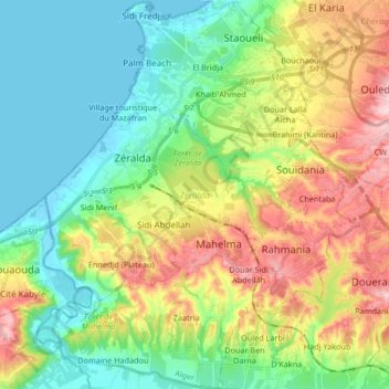
Name: Daïra Zéralda topographic map, elevation, terrain.
Location: Daïra Zéralda, Alger, RADP (36.63263 2.79969 36.76591 2.93806)
Average elevation: 81 m
Minimum elevation: -2 m
Maximum elevation: 231 m
Other topographic maps
Click on a map to view its topography, its elevation and its terrain.
Oued Koreiche
RADP > Alger > Oued Koreiche
Oued Koreiche, Daïra Bab El Oued, Alger, RADP
Average elevation: 144 m