
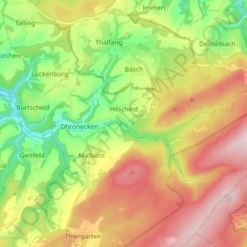
Hilscheid topographic map
Interactive map
Click on the map to display elevation.
About this map
Name: Hilscheid topographic map, elevation, terrain.
Average elevation: 526 m
Minimum elevation: 325 m
Maximum elevation: 771 m
Other topographic maps
Click on a map to view its topography, its elevation and its terrain.
Wolf
Germany > Rhineland-Palatinate > Landkreis Bernkastel-Wittlich > Traben-Trarbach
Wolf, Traben-Trarbach, Landkreis Bernkastel-Wittlich, Rhineland-Palatinate, 54536, Germany
Average elevation: 201 m
Piesport
Germany > Rhineland-Palatinate > Landkreis Bernkastel-Wittlich
Piesport, Bernkastel-Kues, Landkreis Bernkastel-Wittlich, Rhineland-Palatinate, 54498, Germany
Average elevation: 246 m
Wittlich
Germany > Rhineland-Palatinate > Landkreis Bernkastel-Wittlich > Wittlich
Wittlich, Landkreis Bernkastel-Wittlich, Rhineland-Palatinate, 54516, Germany
Average elevation: 237 m
Rapperath
Germany > Rhineland-Palatinate > Landkreis Bernkastel-Wittlich > Morbach
Rapperath, Morbach, Landkreis Bernkastel-Wittlich, Rhineland-Palatinate, Germany
Average elevation: 454 m
Dhronecken
Germany > Rhineland-Palatinate > Landkreis Bernkastel-Wittlich
Dhronecken, Thalfang am Erbeskopf, Landkreis Bernkastel-Wittlich, Rhineland-Palatinate, Germany
Average elevation: 441 m
Klausen
Germany > Rhineland-Palatinate > Landkreis Bernkastel-Wittlich
Klausen, Wittlich-Land, Landkreis Bernkastel-Wittlich, Rhineland-Palatinate, 54524, Germany
Average elevation: 245 m
Morbach
Germany > Rhineland-Palatinate > Landkreis Bernkastel-Wittlich > Morbach
Morbach, Landkreis Bernkastel-Wittlich, Rhineland-Palatinate, 54497, Germany
Average elevation: 529 m
Ferres
Germany > Rhineland-Palatinate > Landkreis Bernkastel-Wittlich > Piesport > Ferres
Ferres, Piesport, Bernkastel-Kues, Landkreis Bernkastel-Wittlich, Rhineland-Palatinate, 54498, Germany
Average elevation: 261 m
Bernkastel-Kues
Germany > Rhineland-Palatinate > Landkreis Bernkastel-Wittlich
Bernkastel-Kues, Landkreis Bernkastel-Wittlich, Rhineland-Palatinate, 54470, Germany
Average elevation: 269 m
Thalfang
Germany > Rhineland-Palatinate > Landkreis Bernkastel-Wittlich
Thalfang, Thalfang am Erbeskopf, Landkreis Bernkastel-Wittlich, Rhineland-Palatinate, 54424, Germany
Average elevation: 462 m