
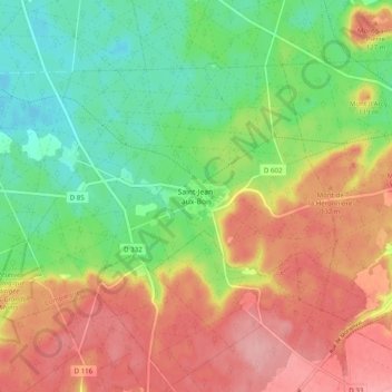
Saint-Jean-aux-Bois topographic map
Interactive map
Click on the map to display elevation.
About this map
Name: Saint-Jean-aux-Bois topographic map, elevation, terrain.
Average elevation: 95 m
Minimum elevation: 38 m
Maximum elevation: 158 m
Other topographic maps
Click on a map to view its topography, its elevation and its terrain.
Glatigny
France > Hauts-de-France > Oise
Glatigny, Beauvais, Oise, Hauts-de-France, Metropolitan France, 60650, France
Average elevation: 180 m
Saint-Paul
France > Hauts-de-France > Oise
Saint-Paul, Beauvais, Oise, Hauts-de-France, Metropolitan France, 60650, France
Average elevation: 113 m
Chantilly
France > Hauts-de-France > Oise
Chantilly, Senlis, Oise, Hauts-de-France, Metropolitan France, 60500, France
Average elevation: 61 m
Ravenel
France > Hauts-de-France > Oise
Ravenel, Clermont, Oise, Hauts-de-France, Metropolitan France, 60130, France
Average elevation: 117 m
Domfront
France > Hauts-de-France > Oise
Domfront, Clermont, Oise, Hauts-de-France, Metropolitan France, 60420, France
Average elevation: 89 m
Verberie
France > Hauts-de-France > Oise
Verberie, Senlis, Oise, Hauts-de-France, Metropolitan France, 60410, France
Average elevation: 68 m
Boulincourt
France > Hauts-de-France > Oise > Agnetz
Boulincourt, Agnetz, Clermont, Oise, Hauts-de-France, Metropolitan France, 60600, France
Average elevation: 108 m
Chambly
France > Hauts-de-France > Oise
Chambly, Senlis, Oise, Hauts-de-France, Metropolitan France, 60230, France
Average elevation: 65 m
Creil
France > Hauts-de-France > Oise
Creil, Senlis, Oise, Hauts-de-France, Metropolitan France, 60100, France
Average elevation: 61 m
Saint-Crépin-aux-Bois
France > Hauts-de-France > Oise
Saint-Crépin-aux-Bois, Compiègne, Oise, Hauts-de-France, Metropolitan France, 60170, France
Average elevation: 94 m
Offémont
France > Hauts-de-France > Oise > Saint-Crépin-aux-Bois
Offémont, Saint-Crépin-aux-Bois, Compiègne, Oise, Hauts-de-France, Metropolitan France, 60170, France
Average elevation: 116 m
Saint-Félix
France > Hauts-de-France > Oise
Saint-Félix, Clermont, Oise, Hauts-de-France, Metropolitan France, 60370, France
Average elevation: 81 m
Verneuil-en-Halatte
France > Hauts-de-France > Oise
Verneuil-en-Halatte, Senlis, Oise, Hauts-de-France, Metropolitan France, 60550, France
Average elevation: 69 m
Pont-Sainte-Maxence
France > Hauts-de-France > Oise
Pont-Sainte-Maxence, Senlis, Oise, Hauts-de-France, Metropolitan France, 60700, France
Average elevation: 56 m
Chiry-Ourscamp
France > Hauts-de-France > Oise
Chiry-Ourscamp, Compiègne, Oise, Hauts-de-France, Metropolitan France, 60138, France
Average elevation: 54 m
Villers-Saint-Frambourg
France > Hauts-de-France > Oise > Villers Saint Frambourg-Ognon
Villers-Saint-Frambourg, Villers Saint Frambourg-Ognon, Senlis, Oise, Hauts-de-France, Metropolitan France, 60810, France
Average elevation: 126 m
Ermenonville
France > Hauts-de-France > Oise
Ermenonville, Senlis, Oise, Hauts-de-France, Metropolitan France, 60950, France
Average elevation: 101 m
Compiègne
France > Hauts-de-France > Oise > Compiègne
Compiègne, Oise, Hauts-de-France, Metropolitan France, 60200, France
Average elevation: 54 m
Apremont
France > Hauts-de-France > Oise > Apremont
Apremont, Senlis, Oise, Hauts-de-France, Metropolitan France, 60300, France
Average elevation: 83 m
Clermont
France > Hauts-de-France > Oise
Clermont, Oise, Hauts-de-France, Metropolitan France, 60600, France
Average elevation: 77 m
Valescourt
France > Hauts-de-France > Oise > Valescourt
Valescourt, Clermont, Oise, Hauts-de-France, Metropolitan France, 60130, France
Average elevation: 131 m
Bury
France > Hauts-de-France > Oise
Bury, Clermont, Oise, Hauts-de-France, Metropolitan France, 60250, France
Average elevation: 80 m
Senlis
France > Hauts-de-France > Oise
Senlis, Oise, Hauts-de-France, Metropolitan France, 60300, France
Average elevation: 80 m
Villers Saint Frambourg-Ognon
France > Hauts-de-France > Oise
Villers Saint Frambourg-Ognon, Senlis, Oise, Hauts-de-France, Metropolitan France, 60810, France
Average elevation: 114 m
Bienville
France > Hauts-de-France > Oise
Bienville, Compiègne, Oise, Hauts-de-France, Metropolitan France, 60280, France
Average elevation: 67 m