
Dickerson topographic map
Interactive map
Click on the map to display elevation.
About this map
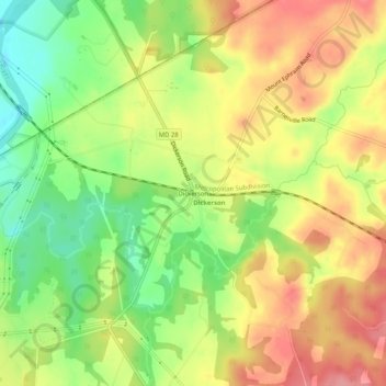
Name: Dickerson topographic map, elevation, terrain.
Location: Dickerson, Montgomery County, Maryland, 20842, United States (39.20010 -77.44415 39.24010 -77.40415)
Average elevation: 111 m
Minimum elevation: 57 m
Maximum elevation: 160 m
Other topographic maps
Click on a map to view its topography, its elevation and its terrain.
Silver Spring
United States > Maryland > Montgomery County > Silver Spring
Silver Spring, Montgomery County, Maryland, United States
Average elevation: 86 m
Gaithersburg
United States > Maryland > Montgomery County
Gaithersburg, Montgomery County, Maryland, United States
Average elevation: 137 m
Laytonsville
United States > Maryland > Montgomery County
Laytonsville, Montgomery County, Maryland, United States
Average elevation: 172 m
Montgomery Village
United States > Maryland > Montgomery County
Montgomery Village, Montgomery County, Maryland, 20886, United States
Average elevation: 139 m
Damascus
United States > Maryland > Montgomery County
Damascus, Montgomery County, Maryland, 20872, United States
Average elevation: 204 m
Clarksburg
United States > Maryland > Montgomery County
Clarksburg, Montgomery County, Maryland, United States
Average elevation: 166 m
White Oak
United States > Maryland > Montgomery County
White Oak, Montgomery County, Maryland, 20904, United States
Average elevation: 96 m
Kemp Mill
United States > Maryland > Montgomery County
Kemp Mill, Montgomery County, Maryland, 20901, United States
Average elevation: 104 m
Flower Hill
United States > Maryland > Montgomery County > Redland
Flower Hill, Redland, Montgomery County, Maryland, 20879, United States
Average elevation: 147 m
Fairland
United States > Maryland > Montgomery County
Fairland, Montgomery County, Maryland, United States
Average elevation: 111 m
Quail Ridge
United States > Maryland > Montgomery County > Montgomery Village
Quail Ridge, Montgomery Village, Montgomery County, Maryland, 20876, United States
Average elevation: 133 m
Cabin John
United States > Maryland > Montgomery County
Cabin John, Montgomery County, Maryland, 20818, United States
Average elevation: 48 m
Chevy Chase Village
United States > Maryland > Montgomery County
Chevy Chase Village, Montgomery County, Maryland, United States
Average elevation: 99 m
Layhill
United States > Maryland > Montgomery County
Layhill, Montgomery County, Maryland, 20906, United States
Average elevation: 116 m
Glenmont
United States > Maryland > Montgomery County
Glenmont, Montgomery County, Maryland, 20902, United States
Average elevation: 109 m
Redland
United States > Maryland > Montgomery County
Redland, Montgomery County, Maryland, 20855, United States
Average elevation: 139 m
Cloverly
United States > Maryland > Montgomery County
Cloverly, Montgomery County, Maryland, 20905, United States
Average elevation: 139 m
Glen Echo
United States > Maryland > Montgomery County
Glen Echo, Montgomery County, Maryland, 20812, United States
Average elevation: 55 m
Colesville
United States > Maryland > Montgomery County
Colesville, Montgomery County, Maryland, 20904, United States
Average elevation: 117 m
Aspen Hill
United States > Maryland > Montgomery County
Aspen Hill, Montgomery County, Maryland, 20906, United States
Average elevation: 114 m
Colesville
United States > Maryland > Montgomery County > Colesville
Colesville, Montgomery County, Maryland, 20904, United States
Average elevation: 113 m
Woodstock Equestrian Park
United States > Maryland > Montgomery County
Woodstock Equestrian Park, 20207, Montgomery County, Maryland, 20842, United States
Average elevation: 124 m
Germantown
United States > Maryland > Montgomery County
Germantown, Montgomery County, Maryland, 20874, United States
Average elevation: 136 m
Darnestown
United States > Maryland > Montgomery County
Darnestown, Montgomery County, Maryland, United States
Average elevation: 97 m
Patuxent River State Park
United States > Maryland > Montgomery County
Patuxent River State Park, Montgomery County, Maryland, United States
Average elevation: 169 m
Deerfield
United States > Maryland > Montgomery County > Potomac
Deerfield, Potomac, Montgomery County, Maryland, 20817, United States
Average elevation: 84 m
South Kensington
United States > Maryland > Montgomery County
South Kensington, Montgomery County, Maryland, United States
Average elevation: 92 m
Kemp Mill Estates
United States > Maryland > Montgomery County > Kemp Mill
Kemp Mill Estates, Kemp Mill, Montgomery County, Maryland, 20902, United States
Average elevation: 107 m
Farmlands
United States > Maryland > Montgomery County > Travilah
Farmlands, Travilah, Montgomery County, Maryland, United States
Average elevation: 93 m
Damascus
United States > Maryland > Montgomery County > Damascus
Damascus, Montgomery County, Maryland, 20872, United States
Average elevation: 195 m
Germantown
United States > Maryland > Montgomery County > Germantown
Germantown, Montgomery County, Maryland, United States
Average elevation: 130 m
Chevy Chase View
United States > Maryland > Montgomery County
Chevy Chase View, Montgomery County, Maryland, United States
Average elevation: 82 m
Garrett Park
United States > Maryland > Montgomery County
Garrett Park, Montgomery County, Maryland, 20896, United States
Average elevation: 90 m
North Potomac
United States > Maryland > Montgomery County
North Potomac, Montgomery County, Maryland, United States
Average elevation: 116 m
Hunting Hill
United States > Maryland > Montgomery County > Rockville
Hunting Hill, Rockville, Montgomery County, Maryland, 20850, United States
Average elevation: 127 m
Olney
United States > Maryland > Montgomery County
Olney, Montgomery County, Maryland, United States
Average elevation: 136 m
Chevy Chase
United States > Maryland > Montgomery County
Chevy Chase, Montgomery County, Maryland, 20815, United States
Average elevation: 99 m
Lake Needwood
United States > Maryland > Montgomery County > Redland
Lake Needwood, Redland, Montgomery County, Maryland, United States
Average elevation: 122 m
Norbeck
United States > Maryland > Montgomery County > Olney
Norbeck, Olney, Montgomery County, Maryland, 20853, United States
Average elevation: 134 m
Bethesda
United States > Maryland > Montgomery County
Bethesda, Montgomery County, Maryland, United States
Average elevation: 81 m
Seneca
United States > Maryland > Montgomery County > Darnestown
Seneca, Darnestown, Montgomery County, Maryland, United States
Average elevation: 82 m
White Oak
United States > Maryland > Montgomery County > White Oak
White Oak, Montgomery County, Maryland, 20993, United States
Average elevation: 101 m
Rockville
United States > Maryland > Montgomery County
Rockville, Montgomery County, Maryland, United States
Average elevation: 122 m
Great Falls
United States > Maryland > Montgomery County > Potomac
Great Falls, Potomac, Montgomery County, Maryland, United States
Average elevation: 73 m
Orchard Place
United States > Maryland > Montgomery County > Gaithersburg
Orchard Place, Gaithersburg, Montgomery County, Maryland, 20899, United States
Average elevation: 128 m
Washington Grove
United States > Maryland > Montgomery County
Washington Grove, Montgomery County, Maryland, 20880, United States
Average elevation: 150 m
Sandy Spring
United States > Maryland > Montgomery County
Sandy Spring, Montgomery County, Maryland, 20860, United States
Average elevation: 137 m
Campbell Corner
United States > Maryland > Montgomery County > Potomac
Campbell Corner, Potomac, Montgomery County, Maryland, 20818, United States
Average elevation: 82 m
Derwood
United States > Maryland > Montgomery County
Derwood, Montgomery County, Maryland, 20855, United States
Average elevation: 133 m
Montgomery Village
United States > Maryland > Montgomery County > Montgomery Village
Montgomery Village, Montgomery County, Maryland, 20886, United States
Average elevation: 132 m