
Infanta topographic map
Interactive map
Click on the map to display elevation.
About this map
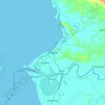
Name: Infanta topographic map, elevation, terrain.
Location: Infanta, Pangasinan, Ilocos Region, Philippines (15.78509 119.86566 15.86509 119.94566)
Average elevation: 7 m
Minimum elevation: -4 m
Maximum elevation: 99 m
Other topographic maps
Click on a map to view its topography, its elevation and its terrain.
Nangalisan
Philippines > Pangasinan > Infanta
Nangalisan, Infanta, Pangasinan, Ilocos Region, 2412, Philippines
Average elevation: 15 m
Maya
Philippines > Pangasinan > Infanta > Maya
Maya, Infanta, Pangasinan, Ilocos Region, 2412, Philippines
Average elevation: 10 m