
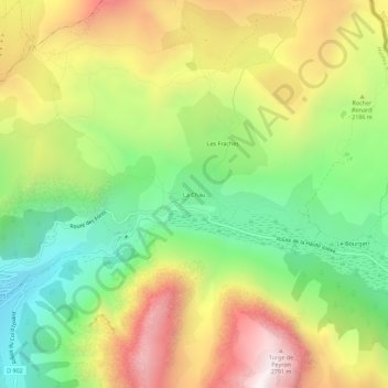
La Chau topographic map
Interactive map
Click on the map to display elevation.
About this map
Name: La Chau topographic map, elevation, terrain.
Average elevation: 2,136 m
Minimum elevation: 1,614 m
Maximum elevation: 2,785 m
Other topographic maps
Click on a map to view its topography, its elevation and its terrain.
Le Bourget
France > Provence-Alpes-Côte d'Azur > Hautes-Alpes > Cervières
Le Bourget, Cervières, Briançon, Hautes-Alpes, Provence-Alpes-Côte d'Azur, France métropolitaine, 05100, France
Average elevation: 2,177 m
Le Laus
France > Provence-Alpes-Côte d'Azur > Hautes-Alpes > Cervières
Le Laus, Cervières, Briançon, Hautes-Alpes, Provence-Alpes-Côte d'Azur, France métropolitaine, 05100, France
Average elevation: 2,052 m
Lauzière
France > Provence-Alpes-Côte d'Azur > Hautes-Alpes > Cervières > Les Fonts
Lauzière, Les Fonts, Cervières, Briançon, Hautes-Alpes, Provence-Alpes-Côte d'Azur, France métropolitaine, 05100, France
Average elevation: 2,324 m
Refuge des Fonts de Cervières
France > Provence-Alpes-Côte d'Azur > Hautes-Alpes > Cervières > Les Fonts
Refuge des Fonts de Cervières, D 89t, Les Fonts, Cervières, Briançon, Hautes-Alpes, Provence-Alpes-Côte d'Azur, France métropolitaine, 05100, France
Average elevation: 2,330 m
Col d'Izoard
France > Provence-Alpes-Côte d'Azur > Hautes-Alpes > Cervières
Col d'Izoard, Cervières, Briançon, Hautes-Alpes, Provence-Alpes-Côte d'Azur, France métropolitaine, 05100, France
Average elevation: 2,373 m
Les Chalps
France > Provence-Alpes-Côte d'Azur > Hautes-Alpes > Cervières
Les Chalps, Cervières, Briançon, Hautes-Alpes, Provence-Alpes-Côte d'Azur, France métropolitaine, 05100, France
Average elevation: 2,327 m
Les Fonts
France > Provence-Alpes-Côte d'Azur > Hautes-Alpes > Cervières
Les Fonts, Cervières, Briançon, Hautes-Alpes, Provence-Alpes-Côte d'Azur, France métropolitaine, 05100, France
Average elevation: 2,430 m
Terre-Rouge
France > Provence-Alpes-Côte d'Azur > Hautes-Alpes > Cervières > Terre-Rouge
Terre-Rouge, Cervières, Briançon, Hautes-Alpes, Provence-Alpes-Côte d'Azur, France métropolitaine, 05100, France
Average elevation: 1,921 m
L'Alp
France > Provence-Alpes-Côte d'Azur > Hautes-Alpes > Cervières > L'Alp
L'Alp, Cervières, Briançon, Hautes-Alpes, Provence-Alpes-Côte d'Azur, France métropolitaine, 05100, France
Average elevation: 1,980 m