
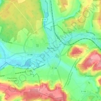
Gisors topographic map
Interactive map
Click on the map to display elevation.
About this map
Name: Gisors topographic map, elevation, terrain.
Average elevation: 84 m
Minimum elevation: 42 m
Maximum elevation: 147 m
Other topographic maps
Click on a map to view its topography, its elevation and its terrain.
Beaumont-le-Roger
Beaumont-le-Roger, Bernay, Eure, Normandy, Metropolitan France, 27170, France
Average elevation: 143 m
Incarville
Incarville, Les Andelys, Eure, Normandy, Metropolitan France, 27400, France
Average elevation: 57 m
Conches-en-Ouche
Conches-en-Ouche, Évreux, Eure, Normandy, Metropolitan France, 27190, France
Average elevation: 151 m
Bourneville
France > Normandy > Eure > Bourneville-Sainte-Croix
Bourneville, Bourneville-Sainte-Croix, Bernay, Eure, Normandy, Metropolitan France, 27500, France
Average elevation: 121 m
Neaufles-Auvergny
Neaufles-Auvergny, Bernay, Eure, Normandy, Metropolitan France, 27250, France
Average elevation: 185 m
Neaufles-Saint-Martin
Neaufles-Saint-Martin, Les Andelys, Eure, Normandy, Metropolitan France, 27830, France
Average elevation: 69 m
La Croisille
La Croisille, Évreux, Eure, Normandy, Metropolitan France, 27190, France
Average elevation: 134 m
Saint-Marcel
Saint-Marcel, Les Andelys, Eure, Normandy, Metropolitan France, 27950, France
Average elevation: 90 m
Notre-Dame-de-l'Isle
Notre-Dame-de-l'Isle, Les Andelys, Eure, Normandy, Metropolitan France, 27940, France
Average elevation: 57 m
La Trinité
La Trinité, Évreux, Eure, Normandy, Metropolitan France, 27930, France
Average elevation: 131 m
Thibouville
Thibouville, Bernay, Eure, Normandy, Metropolitan France, 27800, France
Average elevation: 144 m
La Haye-Saint-Sylvestre
La Haye-Saint-Sylvestre, Bernay, Eure, Normandy, Metropolitan France, 27330, France
Average elevation: 209 m
Saint-Symphorien
France > Normandy > Eure > Saint-Symphorien
Saint-Symphorien, Bernay, Eure, Normandy, Metropolitan France, 27500, France
Average elevation: 123 m
Cesseville
France > Normandy > Eure > Cesseville
Cesseville, Bernay, Eure, Normandy, Metropolitan France, 27110, France
Average elevation: 151 m
Berville-sur-Mer
France > Normandy > Eure > Berville-sur-Mer
Berville-sur-Mer, Bernay, Eure, Normandy, Metropolitan France, 27210, France
Average elevation: 30 m
Roman
France > Normandy > Eure > Mesnils-sur-Iton
Roman, Mesnils-sur-Iton, Bernay, Eure, Normandy, Metropolitan France, 27240, France
Average elevation: 162 m
Mandeville
Mandeville, Bernay, Eure, Normandy, Metropolitan France, 27370, France
Average elevation: 157 m
Gaillardbois-Cressenville
France > Normandy > Eure > Val d'Orger
Gaillardbois-Cressenville, Val d'Orger, Les Andelys, Eure, Normandy, Metropolitan France, 27440, France
Average elevation: 127 m
Val-de-Reuil
Val-de-Reuil, Les Andelys, Eure, Normandy, Metropolitan France, 27100, France
Average elevation: 42 m