Hunningham topographic map
Interactive map
Click on the map to display elevation.
About this map
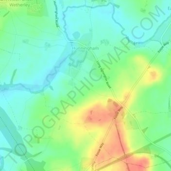
Name: Hunningham topographic map, elevation, terrain.
Location: Hunningham, Warwick, Warwickshire, England, United Kingdom (52.29363 -1.46225 52.31973 -1.41868)
Average elevation: 73 m
Minimum elevation: 54 m
Maximum elevation: 105 m
Other topographic maps
Click on a map to view its topography, its elevation and its terrain.
Sherbourne
United Kingdom > England > Warwickshire > Warwick
Sherbourne, Warwick, Warwickshire, England, United Kingdom
Average elevation: 56 m
Haseley Knob
United Kingdom > England > Warwickshire > Warwick > Wroxall
Haseley Knob, Beausale, Haseley, Honiley and Wroxall, Wroxall, Warwick, Warwickshire, England, CV35 7NL, United Kingdom
Average elevation: 117 m
Chessetts Wood
United Kingdom > England > Warwickshire > Warwick > Lapworth
Chessetts Wood, Lapworth, Warwick, Warwickshire, England, B94 6ET, United Kingdom
Average elevation: 115 m
Bubbenhall
United Kingdom > England > Warwickshire > Warwick
Bubbenhall, Warwick, Warwickshire, England, United Kingdom
Average elevation: 78 m
Ashow
United Kingdom > England > Warwickshire > Warwick
Ashow, Warwick, Warwickshire, England, United Kingdom
Average elevation: 69 m
Hampton on the Hill
United Kingdom > England > Warwickshire > Warwick > Hampton on the Hill
Hampton on the Hill, Warwick, Warwickshire, West Midlands, England, CV35 8RJ, United Kingdom
Average elevation: 75 m
Stoneleigh
United Kingdom > England > Warwickshire > Warwick
Stoneleigh, Warwick, Warwickshire, England, United Kingdom
Average elevation: 76 m
Baginton
United Kingdom > England > Warwickshire > Warwick
Baginton, Warwick, Warwickshire, England, United Kingdom
Average elevation: 74 m
Offchurch
United Kingdom > England > Warwickshire > Warwick
Offchurch, Warwick, Warwickshire, England, United Kingdom
Average elevation: 72 m
Barford
United Kingdom > England > Warwickshire > Warwick
Barford, Warwick, Warwickshire, England, United Kingdom
Average elevation: 56 m
Bishop's Tachbrook
United Kingdom > England > Warwickshire > Warwick
Bishop's Tachbrook, Warwick, Warwickshire, England, United Kingdom
Average elevation: 70 m
Cubbington
United Kingdom > England > Warwickshire > Warwick
Cubbington, Warwick, Warwickshire, England, United Kingdom
Average elevation: 77 m
Budbrooke
United Kingdom > England > Warwickshire > Warwick
Budbrooke, Hampton Magna, Warwick, Warwickshire, England, United Kingdom
Average elevation: 71 m
Burton Green
United Kingdom > England > Warwickshire > Warwick
Burton Green, Warwick, Warwickshire, England, United Kingdom
Average elevation: 112 m
Wasperton
United Kingdom > England > Warwickshire > Warwick
Wasperton, Warwick, Warwickshire, England, United Kingdom
Average elevation: 53 m
Honiley
United Kingdom > England > Warwickshire > Warwick
Honiley, Beausale, Haseley, Honiley and Wroxall, Warwick, Warwickshire, England, CV8 1TJ, United Kingdom
Average elevation: 114 m
Leek Wootton
United Kingdom > England > Warwickshire > Warwick
Leek Wootton, Warwick, Warwickshire, England, CV35 7RS, United Kingdom
Average elevation: 76 m