
Green Lake County topographic map
Interactive map
Click on the map to display elevation.
About this map
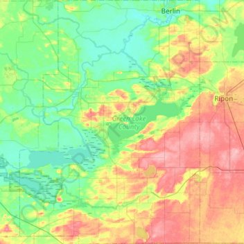
Name: Green Lake County topographic map, elevation, terrain.
Location: Green Lake County, Wisconsin, USA (43.63175 -89.24556 43.98357 -88.88511)
Average elevation: 263 m
Minimum elevation: 228 m
Maximum elevation: 334 m
Other topographic maps
Click on a map to view its topography, its elevation and its terrain.
Prairie du Chien
USA > Wisconsin > Prairie du Chien
Prairie du Chien, Crawford County, Wisconsin, 53821, USA
Average elevation: 227 m
Dane County
Town of Westport, Dane County, Wisconsin, 53597, USA
Average elevation: 276 m
Grand Chute
USA > Wisconsin > Grand Chute
Grand Chute, Town of Grand Chute, Outagamie County, Wisconsin, 54913, USA
Average elevation: 247 m
Spring Green
USA > Wisconsin > Spring Green
Spring Green, Sauk County, Wisconsin, USA
Average elevation: 221 m
Door County
Town of Brussels, Door County, Wisconsin, 54204, USA
Average elevation: 221 m
Fond du Lac
USA > Wisconsin > Fond du Lac
Fond du Lac, Fond du Lac County, Wisconsin, USA
Average elevation: 247 m
Buffalo City
USA > Wisconsin > Buffalo City
Buffalo City, Buffalo County, Wisconsin, USA
Average elevation: 209 m
Thiensville
USA > Wisconsin > Thiensville
Thiensville, Ozaukee County, Wisconsin, USA
Average elevation: 211 m
West Bloomfield
USA > Wisconsin > West Bloomfield
West Bloomfield, Town of Bloomfield, Waushara County, Wisconsin, USA
Average elevation: 250 m
Dells of the Eau Claire County Park
Dells of the Eau Claire County Park, P2150, Town of Plover, Marathon County, Wisconsin, 54408, USA
Average elevation: 426 m
Lily River
Lily River, Town of Nashville, Forest County, Wisconsin, USA
Average elevation: 475 m