
Waddington topographic map
Interactive map
Click on the map to display elevation.
About this map
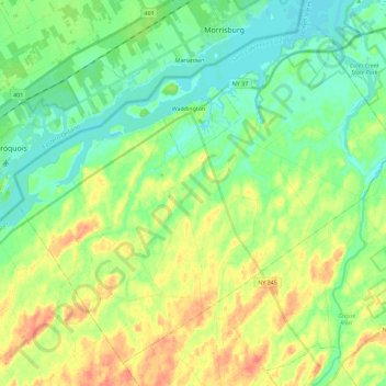
Name: Waddington topographic map, elevation, terrain.
Average elevation: 88 m
Minimum elevation: 70 m
Maximum elevation: 117 m
Other topographic maps
Click on a map to view its topography, its elevation and its terrain.
Village of Waddington
États-Unis d'Amérique > New York > Saint Lawrence County
Village of Waddington, Town of Waddington, Saint Lawrence County, New York, 13694, États-Unis d'Amérique
Average elevation: 80 m
Town of Hermon
États-Unis d'Amérique > New York > Saint Lawrence County
Town of Hermon, Saint Lawrence County, New York, États-Unis d'Amérique
Average elevation: 201 m
Village of Gouverneur
États-Unis d'Amérique > New York > Saint Lawrence County
Village of Gouverneur, Town of Gouverneur, Saint Lawrence County, New York, États-Unis d'Amérique
Average elevation: 139 m