
Medford topographic map
Interactive map
Click on the map to display elevation.
About this map
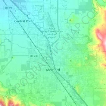
Name: Medford topographic map, elevation, terrain.
Location: Medford, Jackson County, Oregon, United States (42.28876 -122.91123 42.39839 -122.77720)
Average elevation: 441 m
Minimum elevation: 368 m
Maximum elevation: 795 m
Other topographic maps
Click on a map to view its topography, its elevation and its terrain.
Buncom
United States > Oregon > Jackson County
Buncom, Jackson County, Oregon, United States
Average elevation: 654 m
Lower Table Rock Trail
United States > Oregon > Jackson County
Lower Table Rock Trail, Jackson County, Oregon, United States
Average elevation: 453 m
Gold Hill
United States > Oregon > Jackson County
Gold Hill, Jackson County, Oregon, United States
Average elevation: 416 m
Rogue River
United States > Oregon > Jackson County
Rogue River, Jackson County, Oregon, 97537, United States
Average elevation: 362 m
Siskiyou Gap
United States > Oregon > Jackson County
Siskiyou Gap, Jackson County, Oregon, United States
Average elevation: 1,746 m
Jacksonville
United States > Oregon > Jackson County
Jacksonville, Jackson County, Oregon, 97530, United States
Average elevation: 522 m
Lakecreek
United States > Oregon > Jackson County
Lakecreek, Jackson County, Oregon, United States
Average elevation: 538 m