
Yuma topographic map
Interactive map
Click on the map to display elevation.
About this map
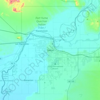
Name: Yuma topographic map, elevation, terrain.
Location: Yuma, Yuma County, Arizona, 85364, United States (32.53265 -114.78754 32.85265 -114.46754)
Average elevation: 69 m
Minimum elevation: 26 m
Maximum elevation: 508 m
Other topographic maps
Click on a map to view its topography, its elevation and its terrain.
Kofa National Wildlife Refuge
United States > Arizona > Yuma County
Kofa National Wildlife Refuge, Yuma County, Arizona, United States
Average elevation: 460 m
Tyson
United States > Arizona > Yuma County
Tyson, Yuma County, Arizona, United States
Average elevation: 94 m
Fortuna Foothills
United States > Arizona > Yuma County > Fortuna Foothills
Fortuna Foothills, Yuma County, Arizona, United States
Average elevation: 133 m
Yuma
United States > Arizona > Yuma County
Yuma, Yuma County, Arizona, United States
Average elevation: 78 m