
Make a donation
Canterbury topographic map
Click on the map to display elevation.
Make a donation
About this map
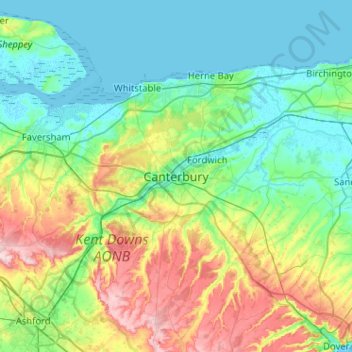
Name: Canterbury topographic map, elevation, terrain.
Location: Canterbury, Kent, England, CT1 2JA, United Kingdom (51.12003 0.92025 51.44003 1.24025)
Average elevation: 50 m
Minimum elevation: -2 m
Maximum elevation: 192 m
Make a donation
Other topographic maps
Click on a map to view its topography, its elevation and its terrain.
Make a donation
Make a donation
Make a donation
Make a donation
Make a donation
Make a donation
Make a donation
Make a donation
Make a donation
Make a donation
Make a donation
Make a donation
Make a donation
Make a donation
Kings Hill
United Kingdom > England > Kent > Tonbridge and Malling > Kings Hill
Average elevation: 82 m
Make a donation
Make a donation
Sevenoaks Weald
United Kingdom > England > Kent > Sevenoaks > Sevenoaks Weald
Average elevation: 112 m
Make a donation
Faversham Creek
United Kingdom > England > Kent > Borough of Swale > Faversham > Oare
Average elevation: 11 m
Barden Lake
United Kingdom > England > Kent > Tonbridge and Malling > Tonbridge
Average elevation: 33 m
Make a donation
St Margaret's Bay
United Kingdom > England > Kent > Dover > St. Margaret's at Cliffe
Average elevation: 38 m
Make a donation
Make a donation
Make a donation
Elmsted
United Kingdom > England > Kent > Folkestone and Hythe District > Lymbridge Green
Average elevation: 144 m
Make a donation
Make a donation
Make a donation
Make a donation