
Thank you for supporting this site ❤️
Make a donation
Make a donation
Les Moulins topographic map
Click on the map to display elevation.
Thank you for supporting this site ❤️
Make a donation
Make a donation
About this map
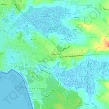
Name: Les Moulins topographic map, elevation, terrain.
Average elevation: 10 m
Minimum elevation: -2 m
Maximum elevation: 44 m
Thank you for supporting this site ❤️
Make a donation
Make a donation
Other topographic maps
Click on a map to view its topography, its elevation and its terrain.
17110
France > Nouvelle-Aquitaine > Charente-Maritime > Saint-Georges-de-Didonne > Les Moulins
Average elevation: 11 m