
Kolda Region topographic map
Interactive map
Click on the map to display elevation.
About this map
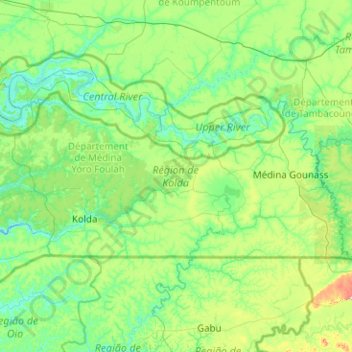
Name: Kolda Region topographic map, elevation, terrain.
Location: Kolda Region, Senegal (12.65839 -15.35570 13.60046 -13.34381)
Average elevation: 43 m
Minimum elevation: -3 m
Maximum elevation: 370 m
Other topographic maps
Click on a map to view its topography, its elevation and its terrain.
Kedougou
Senegal > Kédougou Region > Kedougou
Kedougou, Kédougou Region, 26005, Senegal
Average elevation: 134 m
Ronkh
Senegal > Saint-Louis > Ronkh
Ronkh, Ndiaye, Dagana, Saint-Louis, 32400, Senegal
Average elevation: 5 m