
Union Mills topographic map
Interactive map
Click on the map to display elevation.
About this map
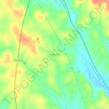
Name: Union Mills topographic map, elevation, terrain.
Average elevation: 326 m
Minimum elevation: 274 m
Maximum elevation: 402 m
Other topographic maps
Click on a map to view its topography, its elevation and its terrain.
Rutherfordton
United States > North Carolina > Rutherford County
Rutherfordton, Rutherford County, North Carolina, United States
Average elevation: 302 m
Rutherfordton
United States > North Carolina > Rutherford County > Rutherfordton
Rutherfordton, Rutherford County, North Carolina, 28139, United States
Average elevation: 300 m
Lake Lure
United States > North Carolina > Rutherford County
Lake Lure, Rutherford County, North Carolina, 28746, United States
Average elevation: 363 m
Spindale
United States > North Carolina > Rutherford County > Spindale
Spindale, Rutherford County, North Carolina, 28160, United States
Average elevation: 299 m
Chimney Rock
United States > North Carolina > Rutherford County > Chimney Rock
Chimney Rock, Rutherford County, North Carolina, 28720, United States
Average elevation: 550 m