
Londonderry/Derry topographic map
Interactive map
Click on the map to display elevation.
About this map
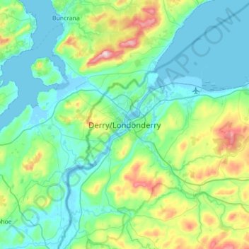
Name: Londonderry/Derry topographic map, elevation, terrain.
Average elevation: 88 m
Minimum elevation: -5 m
Maximum elevation: 478 m
Other topographic maps
Click on a map to view its topography, its elevation and its terrain.
Maghera
Royaume-Uni > Irlande du Nord > County Londonderry
Maghera, County Londonderry, Ulster, Irlande du Nord, BT46 5AE, Royaume-Uni
Average elevation: 72 m
Mullaghmore
Royaume-Uni > Irlande du Nord > County Londonderry
Mullaghmore, County Londonderry, Ulster, Irlande du Nord, BT45 7DZ, Royaume-Uni
Average elevation: 390 m
Magherafelt
Royaume-Uni > Irlande du Nord > County Londonderry
Magherafelt, County Londonderry, Ulster, Irlande du Nord, BT45 6EE, Royaume-Uni
Average elevation: 59 m