
Shigatse Prefecture topographic map
Interactive map
Click on the map to display elevation.
About this map
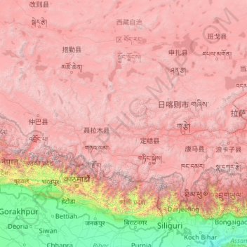
Name: Shigatse Prefecture topographic map, elevation, terrain.
Location: Shigatse Prefecture, Tibet, China (27.21205 82.09907 31.80997 90.34500)
Average elevation: 3,772 m
Minimum elevation: 23 m
Maximum elevation: 8,097 m
Other topographic maps
Click on a map to view its topography, its elevation and its terrain.
Chengguan District
Chengguan District, Lhasa, Tibet, 850000, China
Average elevation: 4,325 m
Mount Everest
China > Tibet > Qutang > Khumjung
Mount Everest, Qutang, Tingri County, Shigatse, Tibet, China
Average elevation: 7,839 m