
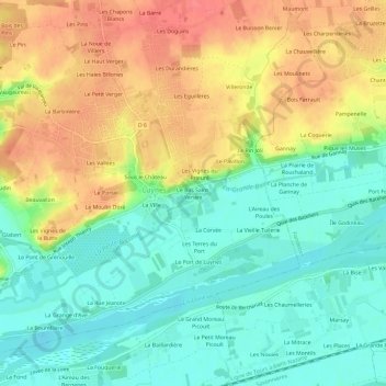
Le Bas Saint-Venant topographic map
Interactive map
Click on the map to display elevation.
About this map
Name: Le Bas Saint-Venant topographic map, elevation, terrain.
Average elevation: 65 m
Minimum elevation: 35 m
Maximum elevation: 105 m
Other topographic maps
Click on a map to view its topography, its elevation and its terrain.
La Barbinière
France > Centre-Val de Loire > Indre-et-Loire > Luynes
La Barbinière, Luynes, Arrondissement de Tours, Indre-et-Loire, Centre-Val de Loire, France métropolitaine, 37230, France
Average elevation: 79 m
Sous le Château
France > Centre-Val de Loire > Indre-et-Loire > Luynes
Sous le Château, Luynes, Arrondissement de Tours, Indre-et-Loire, Centre-Val de Loire, France métropolitaine, 37230, France
Average elevation: 67 m
Les Granges
France > Centre-Val de Loire > Indre-et-Loire > Luynes
Les Granges, Luynes, Tours, Indre-et-Loire, Centre-Val de Loire, France métropolitaine, 37230, France
Average elevation: 60 m