
Thank you for supporting this site ❤️
Make a donation
Make a donation
Udmurtia topographic map
Click on the map to display elevation.
Thank you for supporting this site ❤️
Make a donation
Make a donation
About this map
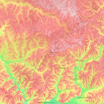
Name: Udmurtia topographic map, elevation, terrain.
Location: Udmurtia, Volga Federal District, Russia (55.85058 51.12416 58.54584 54.43613)
Average elevation: 163 m
Minimum elevation: 55 m
Maximum elevation: 331 m
Thank you for supporting this site ❤️
Make a donation
Make a donation
Other topographic maps
Click on a map to view its topography, its elevation and its terrain.
Thank you for supporting this site ❤️
Make a donation
Make a donation
Thank you for supporting this site ❤️
Make a donation
Make a donation
Thank you for supporting this site ❤️
Make a donation
Make a donation
Thank you for supporting this site ❤️
Make a donation
Make a donation