
Untersiemau topographic map
Interactive map
Click on the map to display elevation.
About this map
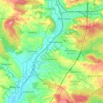
Name: Untersiemau topographic map, elevation, terrain.
Location: Untersiemau, Landkreis Coburg, Bayern, 96253, Deutschland (50.17322 10.91416 50.22707 11.01104)
Average elevation: 319 m
Minimum elevation: 264 m
Maximum elevation: 405 m
Untersiemau liegt am Ostrand des Itzgrunds etwa zehn Kilometer südlich von Coburg auf einer Höhe von etwa 300 Metern. Östlich des Ortes erstreckt sich der Lichtenfelser Forst.
Other topographic maps
Click on a map to view its topography, its elevation and its terrain.
Bad Rodach
Deutschland > Bayern > Landkreis Coburg
Bad Rodach, Landkreis Coburg, Bayern, 96476, Deutschland
Average elevation: 352 m