
Попигай topographic map
Interactive map
Click on the map to display elevation.
About this map
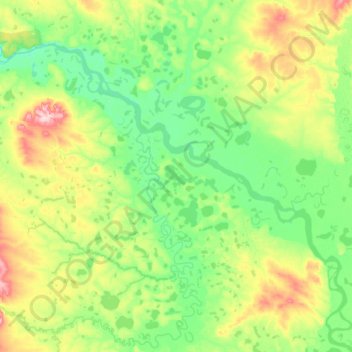
Name: Попигай topographic map, elevation, terrain.
Average elevation: 49 m
Minimum elevation: 10 m
Maximum elevation: 190 m
Other topographic maps
Click on a map to view its topography, its elevation and its terrain.
Taimyrsee
Russland > Region Krasnojarsk > сельское поселение Хатанга
Taimyrsee, сельское поселение Хатанга, Rajon Taimyr der Dolganen und Nenzen, Region Krasnojarsk, Föderationskreis Sibirien, Russland
Average elevation: 120 m