
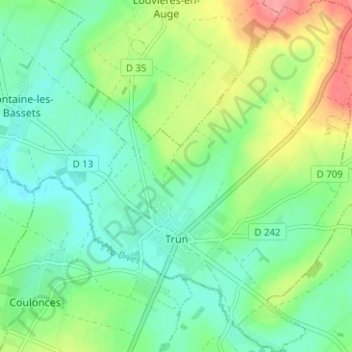
Trun topographic map
Interactive map
Click on the map to display elevation.
About this map
Name: Trun topographic map, elevation, terrain.
Average elevation: 98 m
Minimum elevation: 71 m
Maximum elevation: 154 m
Other topographic maps
Click on a map to view its topography, its elevation and its terrain.
Neuvy-au-Houlme
Neuvy-au-Houlme, Argentan, Orne, Normandy, Metropolitan France, 61210, France
Average elevation: 192 m
Domfront en Poiraie
Domfront en Poiraie, Argentan, Orne, Normandy, Metropolitan France, 61700, France
Average elevation: 174 m
Vimoutiers
Vimoutiers, Mortagne-au-Perche, Orne, Normandy, Metropolitan France, 61120, France
Average elevation: 172 m
Les Champeaux
Les Champeaux, Mortagne-au-Perche, Orne, Normandy, Metropolitan France, 61120, France
Average elevation: 210 m
Chambois
France > Normandy > Orne > Gouffern en Auge
Chambois, Gouffern en Auge, Argentan, Orne, Normandy, Metropolitan France, 61160, France
Average elevation: 115 m
Les Courtils
France > Normandy > Orne > Putanges-le-Lac > Putanges-Pont-Écrepin
Les Courtils, Putanges-Pont-Écrepin, Putanges-le-Lac, Argentan, Orne, Normandy, Metropolitan France, 61210, France
Average elevation: 186 m
La Ferté-Macé
France > Normandy > Orne > La Ferté-Macé
La Ferté-Macé, Argentan, Orne, Normandy, Metropolitan France, 61600, France
Average elevation: 216 m
La Rouge
France > Normandy > Orne > Val-au-Perche
La Rouge, Val-au-Perche, Mortagne-au-Perche, Orne, Normandy, Metropolitan France, 61260, France
Average elevation: 127 m