
Arlington topographic map
Interactive map
Click on the map to display elevation.
About this map
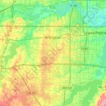
Name: Arlington topographic map, elevation, terrain.
Location: Arlington, Tarrant County, Texas, États-Unis d'Amérique (32.58657 -97.23382 32.81712 -97.03701)
Average elevation: 174 m
Minimum elevation: 125 m
Maximum elevation: 262 m
Other topographic maps
Click on a map to view its topography, its elevation and its terrain.
Azle
États-Unis d'Amérique > Texas > Tarrant County > Azle
Azle, Tarrant County, Texas, 76020, États-Unis d'Amérique
Average elevation: 224 m
Fort Worth
États-Unis d'Amérique > Texas > Tarrant County > Fort Worth
Fort Worth, Tarrant County, Texas, 76102, États-Unis d'Amérique
Average elevation: 202 m