
Danlí topographic map
Interactive map
Click on the map to display elevation.
About this map
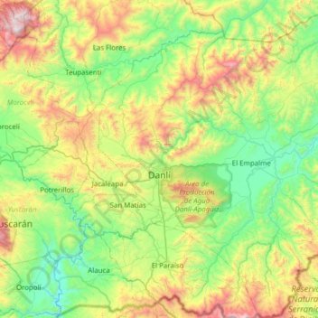
Name: Danlí topographic map, elevation, terrain.
Location: Danlí, El Paraíso, 13201, Honduras (13.76304 -86.68583 14.36062 -86.07098)
Average elevation: 868 m
Minimum elevation: 323 m
Maximum elevation: 2,168 m
Other topographic maps
Click on a map to view its topography, its elevation and its terrain.
Reserva Natural Cordillera de Dipilto y Jalapa
Honduras > El Paraíso > Danlí
Reserva Natural Cordillera de Dipilto y Jalapa, Danlí, El Paraíso, 13201, Honduras
Average elevation: 939 m
Río Guayambre
Honduras > El Paraíso > Patuca
Río Guayambre, Patuca, El Paraíso, Honduras
Average elevation: 693 m