
Evans County topographic map
Interactive map
Click on the map to display elevation.
About this map
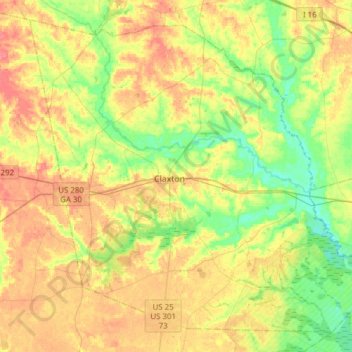
Name: Evans County topographic map, elevation, terrain.
Location: Evans County, Georgia, United States (32.04790 -82.02575 32.27889 -81.71866)
Average elevation: 47 m
Minimum elevation: 19 m
Maximum elevation: 78 m
Evans County is classified as a humid subtropical climate under the Köppen classification and has a mild climate, averaging 49.8 degrees in January and 82.7 degrees in July. The average annual rainfall is 48 inches and the county has a minimum altitude of 65 feet (20 m) above sea level and a maximum altitude of 228 feet (69 m) above sea level. The county is 1.4 times below the U.S. average in historical area-adjusted tornado activity. From 1950 to 2004, only 2 injuries have been caused by tornadoes in the county; this occurred on March 29, 1974, when an F1 tornado hit the county, causing between $5,000 and $50,000 in damages.
Other topographic maps
Click on a map to view its topography, its elevation and its terrain.
Atlanta
United States > Georgia > Fulton County
Atlanta, Fulton County, Georgia, United States
Average elevation: 284 m
Athens
United States > Georgia > Athens
Athens, Athens-Clarke County, Georgia, 303341458, United States
Average elevation: 221 m
Augusta
United States > Georgia > Augusta
Augusta, Richmond County, Georgia, 30901, United States
Average elevation: 90 m
Ellijay
United States > Georgia > Gilmer County
Ellijay, Gilmer County, Georgia, 30540, United States
Average elevation: 424 m
Savannah
United States > Georgia > Chatham County
Savannah, Chatham County, Georgia, United States
Average elevation: 4 m
Blue Ridge
United States > Georgia > Fannin County
Blue Ridge, Fannin County, Georgia, United States
Average elevation: 535 m
Atlanta
United States > Georgia > Fulton County
Atlanta, Fulton County, Georgia, 30303, United States
Average elevation: 285 m
Tiger
United States > Georgia > Rabun County
Tiger, Rabun County, Georgia, United States
Average elevation: 608 m
Helen
United States > Georgia > White County
Helen, White County, Georgia, 30545, United States
Average elevation: 488 m
Vinings
United States > Georgia > Cobb County
Vinings, Cobb County, Georgia, 30339, United States
Average elevation: 281 m
Warrenton
United States > Georgia > Warren County
Warrenton, Warren County, Georgia, United States
Average elevation: 151 m
Gwinnett County
Gwinnett County, Georgia, United States
Average elevation: 302 m
Brunswick
United States > Georgia > Glynn County
Brunswick, Glynn County, Georgia, United States
Average elevation: 2 m
Jefferson
United States > Georgia > Jackson County > Jefferson
Jefferson, Jackson County, Georgia, 30549, United States
Average elevation: 245 m
Blairsville
United States > Georgia > Union County
Blairsville, Union County, Georgia, United States
Average elevation: 587 m
Dahlonega
United States > Georgia > Lumpkin County
Dahlonega, Lumpkin County, Georgia, United States
Average elevation: 411 m
Saint Simons Island
United States > Georgia > Glynn County
Saint Simons Island, Glynn County, Georgia, 31561, United States
Average elevation: 2 m
Macon
United States > Georgia > Bibb County
Macon, Bibb County, Georgia, United States
Average elevation: 127 m
Sterling
United States > Georgia > Glynn County
Sterling, Glynn County, Georgia, United States
Average elevation: 5 m
Gainesville
United States > Georgia > Hall County
Gainesville, Hall County, Georgia, 30501, United States
Average elevation: 346 m
Cross Plains
United States > Georgia > Carroll County
Cross Plains, Carroll County, Georgia, United States
Average elevation: 316 m
Saint Simons Island
United States > Georgia > Glynn County > Saint Simons
Saint Simons Island, Saint Simons, Glynn County, Georgia, 31522, United States
Average elevation: 2 m
Tybee Island
United States > Georgia > Chatham County
Tybee Island, Chatham County, Georgia, 31328, United States
Average elevation: 1 m
Hiawassee
United States > Georgia > Towns County
Hiawassee, Towns County, Georgia, United States
Average elevation: 620 m
Alpharetta
United States > Georgia > Fulton County
Alpharetta, Fulton County, Georgia, United States
Average elevation: 324 m
St. Marys
United States > Georgia > Camden County
St. Marys, Camden County, Georgia, United States
Average elevation: 3 m
Canton
United States > Georgia > Cherokee County
Canton, Cherokee County, Georgia, United States
Average elevation: 320 m
Cascade Falls
United States > Georgia > Meriwether County
Cascade Falls, Meriwether County, Georgia, 31830, United States
Average elevation: 352 m
Kennesaw
United States > Georgia > Cobb County
Kennesaw, Cobb County, Georgia, 30144, United States
Average elevation: 317 m
Woodstock
United States > Georgia > Cherokee County
Woodstock, Cherokee County, Georgia, United States
Average elevation: 296 m
Columbus
United States > Georgia > Muscogee County
Columbus, Muscogee County, Georgia, United States
Average elevation: 130 m
Mount Vernon
United States > Georgia > Walton County
Mount Vernon, Walton County, Georgia, United States
Average elevation: 248 m
Warm Springs
United States > Georgia > Meriwether County
Warm Springs, Meriwether County, Georgia, United States
Average elevation: 295 m
Ochlocknee
United States > Georgia > Thomas County
Ochlocknee, Thomas County, Georgia, United States
Average elevation: 77 m
Paulding County
Paulding County, Georgia, United States
Average elevation: 311 m
Resaca
United States > Georgia > Gordon County
Resaca, Gordon County, Georgia, United States
Average elevation: 199 m
Warner Robins
United States > Georgia > Houston County
Warner Robins, Houston County, Georgia, United States
Average elevation: 101 m
Collins
United States > Georgia > Tattnall County
Collins, Tattnall County, Georgia, 30421, United States
Average elevation: 67 m
Eastman
United States > Georgia > Dodge County
Eastman, Dodge County, Georgia, 31023, United States
Average elevation: 99 m
Terrace Manor
United States > Georgia > Richmond County > Augusta
Terrace Manor, Augusta, Richmond County, Georgia, 30906, United States
Average elevation: 100 m