
Clayton topographic map
Interactive map
Click on the map to display elevation.
About this map
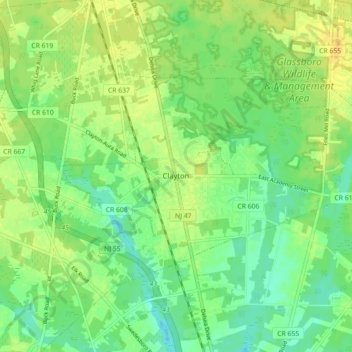
Name: Clayton topographic map, elevation, terrain.
Location: Clayton, Gloucester County, New Jersey, 08312, United States (39.64042 -75.12089 39.67996 -75.03177)
Average elevation: 39 m
Minimum elevation: 27 m
Maximum elevation: 50 m
Other topographic maps
Click on a map to view its topography, its elevation and its terrain.
West Deptford Township
United States > New Jersey > Gloucester County
West Deptford Township, Gloucester County, New Jersey, United States
Average elevation: 9 m
Mantua Creek
United States > New Jersey > Gloucester County > West Deptford Township
Mantua Creek, West Deptford Township, Gloucester County, New Jersey, 08051, United States
Average elevation: 13 m
Franklinville
United States > New Jersey > Gloucester County > Franklin Township
Franklinville, Franklin Township, Gloucester County, New Jersey, 08322, United States
Average elevation: 32 m
Woodbury Heights
United States > New Jersey > Gloucester County
Woodbury Heights, Gloucester County, New Jersey, 08097, United States
Average elevation: 18 m
Buckingham Village
United States > New Jersey > Gloucester County > Mantua Township
Buckingham Village, Mantua Township, Gloucester County, New Jersey, 08071, United States
Average elevation: 24 m
Silver Lake
United States > New Jersey > Gloucester County > Clayton
Silver Lake, Clayton, Gloucester County, New Jersey, United States
Average elevation: 38 m
Alcyon Lake Dam
United States > New Jersey > Gloucester County > Pitman
Alcyon Lake Dam, Pitman, Gloucester County, New Jersey, 08071, United States
Average elevation: 36 m
Pitman
United States > New Jersey > Gloucester County
Pitman, Gloucester County, New Jersey, 08071, United States
Average elevation: 35 m
Clarksboro
United States > New Jersey > Gloucester County > East Greenwich Township
Clarksboro, East Greenwich Township, Gloucester County, New Jersey, 08020, United States
Average elevation: 14 m
Iona
United States > New Jersey > Gloucester County > Franklin Township
Iona, Franklin Township, Gloucester County, New Jersey, 08328, United States
Average elevation: 31 m
Verga
United States > New Jersey > Gloucester County > West Deptford Township
Verga, West Deptford Township, Gloucester County, New Jersey, 08063, United States
Average elevation: 7 m
Monroe Township
United States > New Jersey > Gloucester County > Monroe Township
Monroe Township, Gloucester County, New Jersey, 08094, United States
Average elevation: 38 m
Newfield
United States > New Jersey > Gloucester County
Newfield, Gloucester County, New Jersey, 08344, United States
Average elevation: 33 m
Logan Township
United States > New Jersey > Gloucester County
Logan Township, Gloucester County, New Jersey, 08014, United States
Average elevation: 7 m
Washington Township
United States > New Jersey > Gloucester County
Washington Township, Gloucester County, New Jersey, United States
Average elevation: 33 m
Woolwich Township
United States > New Jersey > Gloucester County
Woolwich Township, Gloucester County, New Jersey, 08085, United States
Average elevation: 14 m
Westcotville
United States > New Jersey > Gloucester County > Deptford Township
Westcotville, Deptford Township, Gloucester County, New Jersey, 08096, United States
Average elevation: 16 m
Elk Township
United States > New Jersey > Gloucester County
Elk Township, Gloucester County, New Jersey, 08343, United States
Average elevation: 41 m
Mantua Township
United States > New Jersey > Gloucester County
Mantua Township, Gloucester County, New Jersey, 08051, United States
Average elevation: 27 m
Deptford
United States > New Jersey > Gloucester County > Deptford
Deptford, Gloucester County, New Jersey, 08096, United States
Average elevation: 15 m
Williamstown
United States > New Jersey > Gloucester County > Monroe Township
Williamstown, Monroe Township, Gloucester County, New Jersey, 08094, United States
Average elevation: 44 m
Deptford Township
United States > New Jersey > Gloucester County
Deptford Township, Gloucester County, New Jersey, United States
Average elevation: 16 m
Glassboro
United States > New Jersey > Gloucester County > Glassboro
Glassboro, Gloucester County, New Jersey, United States
Average elevation: 40 m
Westville
United States > New Jersey > Gloucester County
Westville, Gloucester County, New Jersey, United States
Average elevation: 6 m
Greenwich Township
United States > New Jersey > Gloucester County > Greenwich Township
Greenwich Township, Gloucester County, New Jersey, 08027, United States
Average elevation: 5 m
Monroe Township
United States > New Jersey > Gloucester County > Monroe Township
Monroe Township, Gloucester County, New Jersey, United States
Average elevation: 37 m
Harrison Township
United States > New Jersey > Gloucester County
Harrison Township, Gloucester County, New Jersey, United States
Average elevation: 31 m
National Park
United States > New Jersey > Gloucester County
National Park, Gloucester County, New Jersey, 08063, United States
Average elevation: 3 m
Hurffville
United States > New Jersey > Gloucester County > Washington Township > Hurffville
Hurffville, Washington Township, Gloucester County, New Jersey, 08080, United States
Average elevation: 26 m
Sewell
United States > New Jersey > Gloucester County > Mantua Township
Sewell, Mantua Township, Gloucester County, New Jersey, 08090, United States
Average elevation: 23 m
Wenonah
United States > New Jersey > Gloucester County
Wenonah, Gloucester County, New Jersey, 08090, United States
Average elevation: 18 m
Bridgeport
United States > New Jersey > Gloucester County > Logan Township > Bridgeport
Bridgeport, Logan Township, Gloucester County, New Jersey, 08014, United States
Average elevation: 4 m
Sunset Beach
United States > New Jersey > Gloucester County > Deptford > Sunset Beach
Sunset Beach, Deptford, Gloucester County, New Jersey, 08096, United States
Average elevation: 17 m
Harding
United States > New Jersey > Gloucester County > Elk Township
Harding, Elk Township, Gloucester County, New Jersey, 08343, United States
Average elevation: 38 m