
Washington Island topographic map
Interactive map
Click on the map to display elevation.
About this map
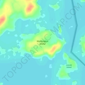
Name: Washington Island topographic map, elevation, terrain.
Location: Washington Island, Lake County, Minnesota, United States (48.04608 -91.60580 48.05785 -91.57779)
Average elevation: 401 m
Minimum elevation: 392 m
Maximum elevation: 434 m
Other topographic maps
Click on a map to view its topography, its elevation and its terrain.
Isabella
United States > Minnesota > Lake County
Isabella, Lake County, Minnesota, United States
Average elevation: 594 m
Boundary Waters Canoe Area Wilderness
United States > Minnesota > Lake County
Boundary Waters Canoe Area Wilderness, Lake County, Minnesota, United States
Average elevation: 423 m
Turtle Lake
United States > Minnesota > Lake County
Turtle Lake, Lake County, Minnesota, United States
Average elevation: 458 m
Two Harbors
United States > Minnesota > Lake County
Two Harbors, Lake County, Minnesota, United States
Average elevation: 221 m
Bowstring Lake
United States > Minnesota > Lake County
Bowstring Lake, Lake County, Minnesota, United States
Average elevation: 498 m
Snowbank Lake
United States > Minnesota > Lake County
Snowbank Lake, Lake County, Minnesota, United States
Average elevation: 441 m
Bill Lake
United States > Minnesota > Lake County
Bill Lake, Lake County, Minnesota, United States
Average elevation: 510 m
Ennis Lake
United States > Minnesota > Lake County
Ennis Lake, Fall Lake Township, Lake County, Minnesota, United States
Average elevation: 445 m
Crooked Lake
United States > Minnesota > Lake County
Crooked Lake, Lake County, Minnesota, United States
Average elevation: 533 m
Dorothy Lake
United States > Minnesota > Lake County
Dorothy Lake, Lake County, Minnesota, United States
Average elevation: 491 m
Sable Lake
United States > Minnesota > Lake County
Sable Lake, Lake County, Minnesota, United States
Average elevation: 487 m
Finland
United States > Minnesota > Lake County
Finland, Lake County, Minnesota, 55603, United States
Average elevation: 425 m
Boga Lake
United States > Minnesota > Lake County
Boga Lake, Lake County, Minnesota, United States
Average elevation: 482 m