
Leona topographic map
Interactive map
Click on the map to display elevation.
About this map
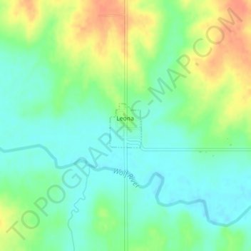
Name: Leona topographic map, elevation, terrain.
Location: Leona, Doniphan County, Kansas, United States (39.78403 -95.32377 39.78880 -95.31938)
Average elevation: 293 m
Minimum elevation: 276 m
Maximum elevation: 321 m
Other topographic maps
Click on a map to view its topography, its elevation and its terrain.
Wathena
United States > Kansas > Doniphan County
Wathena, Doniphan County, Kansas, 66090, United States
Average elevation: 266 m
Bendena
United States > Kansas > Doniphan County
Bendena, Doniphan County, Kansas, 66008, United States
Average elevation: 328 m
Elwood
United States > Kansas > Doniphan County
Elwood, Doniphan County, Kansas, 66024, United States
Average elevation: 257 m
Severance
United States > Kansas > Doniphan County
Severance, Doniphan County, Kansas, United States
Average elevation: 291 m
Denton
United States > Kansas > Doniphan County
Denton, Doniphan County, Kansas, United States
Average elevation: 319 m
Troy
United States > Kansas > Doniphan County
Troy, Doniphan County, Kansas, United States
Average elevation: 331 m
White Cloud
United States > Kansas > Doniphan County
White Cloud, Doniphan County, Kansas, United States
Average elevation: 285 m
Highland
United States > Kansas > Doniphan County
Highland, Doniphan County, Kansas, 66035, United States
Average elevation: 315 m
Fanning
United States > Kansas > Doniphan County
Fanning, Doniphan County, Kansas, United States
Average elevation: 291 m