Geolocate

鄯善县库姆塔格沙漠风景名胜区 topographic map

Interactive map

Click on the map to display elevation.

About this map

Name: 
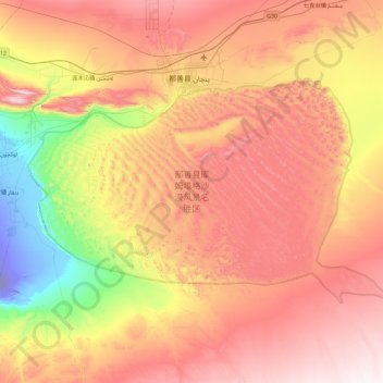
鄯善县库姆塔格沙漠风景名胜区 topographic map, elevation, terrain.

Location: 鄯善县库姆塔格沙漠风景名胜区, 鄯善县, 吐鲁番市, 新疆维吾尔自治区, 中国 (42.47805 89.83112 42.87569 90.74170)

Average elevation: 424 m

Minimum elevation: -99 m

Maximum elevation: 858 m

Other topographic maps

Click on a map to view its topography, its elevation and its terrain.

库尔干村

中国 > 新疆维吾尔自治区 > 鄯善县

库尔干村, 鄯善县, 吐鲁番市, 新疆维吾尔自治区, 中国

Average elevation: 407 m

二唐沟

中国 > 新疆维吾尔自治区 > 鄯善县

二唐沟, 鄯善县, 吐鲁番市, 新疆维吾尔自治区, 中国

Average elevation: 521 m

盆地边1

中国 > 新疆维吾尔自治区 > 鄯善县

盆地边1, 鄯善县, 吐鲁番市, 新疆维吾尔自治区, 中国

Average elevation: 440 m

鄯善县

中国 > 新疆维吾尔自治区 > 鄯善县

鄯善县, 吐鲁番市, 新疆维吾尔自治区, 中国

Average elevation: 483 m

火焰山

中国 > 新疆维吾尔自治区 > 鄯善县 > Singgimtay

火焰山, Singgimtay, 鄯善县, 吐鲁番市, 新疆维吾尔自治区, 中国

Average elevation: 251 m

盆地边2

中国 > 新疆维吾尔自治区 > 鄯善县

盆地边2, 鄯善县, 吐鲁番市, 新疆维吾尔自治区, 中国

Average elevation: 658 m