
Make a donation
Montana topographic map
Click on the map to display elevation.
Make a donation
Montana
Montana's topography is marked by dramatic contrasts, offering a rich tapestry of landscapes. The state is divided into three main regions: the vast, rolling plains in the east, the rugged Rocky Mountains in the west, and the transition zone between these two. The eastern plains are part of the Great Plains, characterized by expansive grasslands, gently rolling hills, and wide river valleys, with minimal precipitation and semi-arid conditions. These plains are interrupted by isolated mountain ranges such as the Bear Paw and Little Rocky Mountains. The western part of the state is dominated by the Rocky Mountains, featuring steep, forested slopes, narrow valleys, and high peaks, including Granite Peak, which rises to 12,807 feet ((3,904 meters). Here, snow-covered mountains, active glaciers, and clear, cold lakes are common, particularly in areas like Glacier National Park. Between these extremes, the Central Front forms a transitional landscape with prairies, badlands, and smaller mountain ranges, bridging the plains and the mountains.
Make a donation
About this map
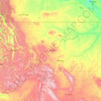
Name: Montana topographic map, elevation, terrain.
Location: Montana, United States (44.35792 -116.04923 49.00111 -104.03956)
Average elevation: 1,357 m
Minimum elevation: 552 m
Maximum elevation: 4,034 m
Make a donation
Other topographic maps
Click on a map to view its topography, its elevation and its terrain.
Make a donation
Fern Glen
United States > Pennsylvania > Luzerne County > Black Creek Township
Average elevation: 391 m
Make a donation
Trachsville
United States > Pennsylvania > Carbon County > Towamensing Township
Average elevation: 256 m
Make a donation
Make a donation
Make a donation
Cleveland
United States > Ohio > Cuyahoga County > Cleveland
The land rises quickly from the lake shore elevation of 569 feet. Public Square, less than one mile (1.6 km) inland, sits at an elevation of 650 feet (198 m), and Hopkins Airport, 5 miles (8 km) inland from the lake, is at an elevation of 791 feet (241 m).
Average elevation: 219 m
Make a donation
Glen Canyon Dam
United States > Arizona > Coconino County
The Bureau of Reclamation favored the Echo Park site over Glen Canyon, because its narrow canyons and high elevation (more than 5,000 feet (1,500 m), as compared to 3,700 feet (1,100 m) at Glen Canyon) would lead to less evaporation. It said that building Echo Park Dam and a "low" Glen Canyon Dam would save…
Average elevation: 1,171 m
Miami
United States > Florida > Miami-Dade County
Miami and its suburbs are located on a broad plain between the Everglades to the west and Biscayne Bay to the east, which extends from Lake Okeechobee southward to Florida Bay. The elevation of the area averages at around 6 ft (1.8 m)[39] above sea level in most neighborhoods, especially near the coast. The…
Average elevation: 4 m
Make a donation