
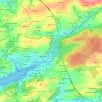
Moulin du Bois topographic map
Interactive map
Click on the map to display elevation.
About this map
Name: Moulin du Bois topographic map, elevation, terrain.
Average elevation: 48 m
Minimum elevation: 0 m
Maximum elevation: 110 m
Other topographic maps
Click on a map to view its topography, its elevation and its terrain.
Kerbiaouen Bras
France > Bretagne > Finistère > Hôpital-Camfrout > L'Hôpital-Camfrout
Kerbiaouen Bras, L'Hôpital-Camfrout, Hôpital-Camfrout, Brest, Finistère, Bretagne, France métropolitaine, 29460, France
Average elevation: 41 m
L'Hermitage
France > Bretagne > Finistère > Hôpital-Camfrout > L'Hôpital-Camfrout
L'Hermitage, L'Hôpital-Camfrout, Hôpital-Camfrout, Brest, Finistère, Bretagne, France métropolitaine, 29460, France
Average elevation: 47 m