
Moshannon topographic map
Interactive map
Click on the map to display elevation.
About this map
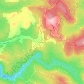
Name: Moshannon topographic map, elevation, terrain.
Average elevation: 464 m
Minimum elevation: 370 m
Maximum elevation: 550 m
Other topographic maps
Click on a map to view its topography, its elevation and its terrain.
State College
United States > Pennsylvania > Centre County
State College, Centre County, Pennsylvania, United States
Average elevation: 351 m
Millbrook Marsh Nature Center
United States > Pennsylvania > Centre County
Millbrook Marsh Nature Center, College Township, Centre County, Pennsylvania, United States
Average elevation: 315 m
The Arboretum at Penn State
United States > Pennsylvania > Centre County > Krumrine
The Arboretum at Penn State, Krumrine, Ferguson Township, Centre County, Pennsylvania, United States
Average elevation: 353 m
Lemont
United States > Pennsylvania > Centre County
Lemont, Centre County, Pennsylvania, 16851, United States
Average elevation: 344 m
Pine Grove Mills
United States > Pennsylvania > Centre County
Pine Grove Mills, Centre County, Pennsylvania, 16868, United States
Average elevation: 433 m
Park Forest Village
United States > Pennsylvania > Centre County
Park Forest Village, Patton Township, Centre County, Pennsylvania, 16803, United States
Average elevation: 398 m
Pleasant Gap
United States > Pennsylvania > Centre County
Pleasant Gap, Spring Township, Centre County, Pennsylvania, United States
Average elevation: 327 m
Orviston
United States > Pennsylvania > Centre County
Orviston, Curtin Township, Centre County, Pennsylvania, 16864, United States
Average elevation: 406 m
Rebersburg
United States > Pennsylvania > Centre County
Rebersburg, Miles Township, Centre County, Pennsylvania, United States
Average elevation: 421 m
Potters Mills
United States > Pennsylvania > Centre County
Potters Mills, Potter Township, Centre County, Pennsylvania, United States
Average elevation: 431 m
Peru
United States > Pennsylvania > Centre County
Peru, Benner Township, Centre County, Pennsylvania, United States
Average elevation: 358 m
Clarence
United States > Pennsylvania > Centre County
Clarence, Snow Shoe Township, Centre County, Pennsylvania, United States
Average elevation: 471 m
Blanchard
United States > Pennsylvania > Centre County
Blanchard, Liberty Township, Centre County, Pennsylvania, United States
Average elevation: 201 m
Sandy Ridge
United States > Pennsylvania > Centre County
Sandy Ridge, Rush Township, Centre County, Pennsylvania, 16677, United States
Average elevation: 576 m
Aaronsburg
United States > Pennsylvania > Centre County
Aaronsburg, Haines Township, Centre County, Pennsylvania, United States
Average elevation: 390 m
Milheim Narrows
United States > Pennsylvania > Centre County
Milheim Narrows, Penn Township, Centre County, Pennsylvania, United States
Average elevation: 439 m
Mingoville
United States > Pennsylvania > Centre County
Mingoville, Walker Township, Centre County, Pennsylvania, 16856, United States
Average elevation: 367 m
Madisonburg
United States > Pennsylvania > Centre County
Madisonburg, Miles Township, Centre County, Pennsylvania, United States
Average elevation: 429 m
Zion
United States > Pennsylvania > Centre County
Zion, Walker Township, Centre County, Pennsylvania, United States
Average elevation: 361 m
Spring Mills
United States > Pennsylvania > Centre County
Spring Mills, Gregg Township, Centre County, Pennsylvania, United States
Average elevation: 368 m
Bear Rocks
United States > Pennsylvania > Centre County
Bear Rocks, Union Township, Centre County, Pennsylvania, United States
Average elevation: 628 m
Millheim
United States > Pennsylvania > Centre County
Millheim, Centre County, Pennsylvania, 16854, United States
Average elevation: 371 m
Howard
United States > Pennsylvania > Centre County
Howard, Centre County, Pennsylvania, United States
Average elevation: 229 m
Worth Township
United States > Pennsylvania > Centre County
Worth Township, Centre County, Pennsylvania, United States
Average elevation: 456 m
Halfmoon Township
United States > Pennsylvania > Centre County
Halfmoon Township, Centre County, Pennsylvania, United States
Average elevation: 396 m
Coburn
United States > Pennsylvania > Centre County
Coburn, Penn Township, Centre County, Pennsylvania, United States
Average elevation: 364 m
Milesburg
United States > Pennsylvania > Centre County
Milesburg, Centre County, Pennsylvania, 16853, United States
Average elevation: 258 m
Centre Hall
United States > Pennsylvania > Centre County
Centre Hall, Centre County, Pennsylvania, United States
Average elevation: 420 m
Ramblewood
United States > Pennsylvania > Centre County
Ramblewood, Ferguson Township, Centre County, Pennsylvania, 16865, United States
Average elevation: 396 m
Snydertown
United States > Pennsylvania > Centre County
Snydertown, Walker Township, Centre County, Pennsylvania, United States
Average elevation: 319 m
Philipsburg
United States > Pennsylvania > Centre County
Philipsburg, Centre County, Pennsylvania, United States
Average elevation: 456 m
Woodward
United States > Pennsylvania > Centre County
Woodward, Haines Township, Centre County, Pennsylvania, United States
Average elevation: 447 m
Boalsburg
United States > Pennsylvania > Centre County > Boalsburg
Boalsburg, Centre County, Pennsylvania, 16827, United States
Average elevation: 426 m
Park Hills Park
United States > Pennsylvania > Centre County > State College > Park Forest Village
Park Hills Park, Park Hills, Park Forest Village, State College, Centre County, Pennsylvania, 16803, United States
Average elevation: 377 m
Black Moshannon State Park
United States > Pennsylvania > Centre County
Black Moshannon State Park, Rush Township, Centre County, Pennsylvania, United States
Average elevation: 602 m
Port Matilda
United States > Pennsylvania > Centre County
Port Matilda, Centre County, Pennsylvania, United States
Average elevation: 360 m
Snow Shoe
United States > Pennsylvania > Centre County
Snow Shoe, Centre County, Pennsylvania, 16874, United States
Average elevation: 511 m
Bellefonte
United States > Pennsylvania > Centre County
Bellefonte, Centre County, Pennsylvania, 16823, United States
Average elevation: 285 m
Julian
United States > Pennsylvania > Centre County
Julian, Huston Township, Centre County, Pennsylvania, United States
Average elevation: 327 m
Mount Nittany
United States > Pennsylvania > Centre County
Mount Nittany, College Township, Centre County, Pennsylvania, 16851, United States
Average elevation: 467 m