
Bethesda topographic map
Interactive map
Click on the map to display elevation.
About this map
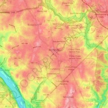
Name: Bethesda topographic map, elevation, terrain.
Location: Bethesda, Montgomery County, Maryland, États-Unis d'Amérique (38.94040 -77.15856 39.02242 -77.07716)
Average elevation: 86 m
Minimum elevation: 4 m
Maximum elevation: 129 m
Other topographic maps
Click on a map to view its topography, its elevation and its terrain.
Gaithersburg
États-Unis d'Amérique > Maryland > Montgomery County > Gaithersburg
Gaithersburg, Montgomery County, Maryland, États-Unis d'Amérique
Average elevation: 137 m
Takoma Park
États-Unis d'Amérique > Maryland > Montgomery County
Takoma Park, Montgomery County, Maryland, 20912, États-Unis d'Amérique
Average elevation: 75 m