
Vojvodina topographic map
Interactive map
Click on the map to display elevation.
About this map
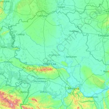
Name: Vojvodina topographic map, elevation, terrain.
Location: Vojvodina, Serbia (44.62973 18.81499 46.19028 21.56013)
Average elevation: 110 m
Minimum elevation: 66 m
Maximum elevation: 860 m
Today, the western part of Syrmia is in Croatia, the northern part of Bačka is in Hungary, the eastern part of Banat is in Romania (with a small piece in Hungary), while Baranja (which is between the Danube and the Drava) is in Hungary and Croatia. Vojvodina has a total surface area of 21,500 km2 (8,300 sq mi). Vojvodina is also part of the Danube-Kris-Mures-Tisa euroregion. The Gudurica peak (Gudurički vrh) on the Vršac Mountains, is the highest peak in Vojvodina, at an altitude of 641 m above sea level.
Other topographic maps
Click on a map to view its topography, its elevation and its terrain.
Serbia
Serbia > Central Serbia > Kladovo Municipality
Serbia, 35, Novi Sip, Kladovo Municipality, Bor Administrative District, Central Serbia, Serbia
Average elevation: 518 m
Kragujevac
Serbia > Central Serbia > Sumadija Administrative District
Kragujevac, City of Kragujevac, Sumadija Administrative District, Central Serbia, 34114, Serbia
Average elevation: 320 m
Доњи Таванкут
Serbia > Vojvodina > Donji Tavankut
Доњи Таванкут, Donji Tavankut, Subotica City, North Backa Administrative District, Vojvodina, 24214, Serbia
Average elevation: 123 m
Kopaonik
Serbia > Central Serbia > Kopaonik
Kopaonik, Raska Administrative District, Central Serbia, 36354, Serbia
Average elevation: 1,703 m
Besna Kobila
Besna Kobila, Vranje City, Pcinja Administrative District, Central Serbia, Serbia
Average elevation: 1,612 m
Zlatibor
Serbia > Central Serbia > Zlatibor
Zlatibor, Zlatibor Administrative District, Central Serbia, 31315, Serbia
Average elevation: 967 m
Nisava
Nisava, Pirot Administrative District, Central Serbia, 70857, Serbia
Average elevation: 703 m
Caricina
Serbia > Central Serbia > Царичина
Caricina, Царичина, Zlatibor Administrative District, Central Serbia, Serbia
Average elevation: 1,345 m
City of Belgrade
City of Belgrade, Central Serbia, Serbia
Average elevation: 136 m