
Atascadero topographic map
Interactive map
Click on the map to display elevation.
About this map
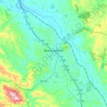
Name: Atascadero topographic map, elevation, terrain.
Average elevation: 337 m
Minimum elevation: 231 m
Maximum elevation: 727 m
Other topographic maps
Click on a map to view its topography, its elevation and its terrain.
Arroyo Grande
États-Unis d'Amérique > Californie > San Luis Obispo County
Arroyo Grande, San Luis Obispo County, Californie, États-Unis d'Amérique
Average elevation: 62 m
Paso Robles
États-Unis d'Amérique > Californie > San Luis Obispo County
Paso Robles, San Luis Obispo County, Californie, États-Unis d'Amérique
Average elevation: 298 m