
Clifton topographic map
Interactive map
Click on the map to display elevation.
About this map
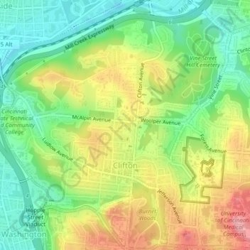
Name: Clifton topographic map, elevation, terrain.
Location: Clifton, Cincinnati, Hamilton County, Ohio, USA (39.13511 -84.53908 39.16404 -84.50326)
Average elevation: 194 m
Minimum elevation: 141 m
Maximum elevation: 265 m
Other topographic maps
Click on a map to view its topography, its elevation and its terrain.
Ohio River
USA > Ohio > Cincinnati
Ohio River, East Pete Rose Way, Lytle Park Historic District, Mount Adams, Cincinnati, Hamilton County, Ohio, 45202, USA
Average elevation: 177 m
Mount Adams
USA > Ohio > Cincinnati
Mount Adams, Cincinnati, Hamilton County, Ohio, 45202, USA
Average elevation: 181 m
The Heights
USA > Ohio > Cincinnati
The Heights, Cincinnati, Hamilton County, Ohio, USA
Average elevation: 220 m
Corryville
USA > Ohio > Cincinnati
Corryville, Cincinnati, Hamilton County, Ohio, USA
Average elevation: 237 m
Filson Park
USA > Ohio > Cincinnati
Filson Park, Prospect Hill Historic District, Prospect Hill, Cincinnati, Hamilton County, Ohio, USA
Average elevation: 206 m