
Dötlingen topographic map
Interactive map
Click on the map to display elevation.
About this map
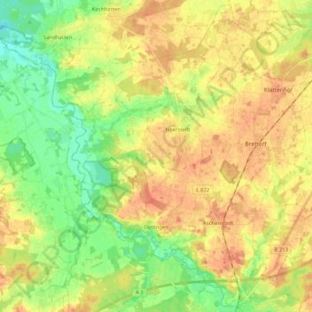
Name: Dötlingen topographic map, elevation, terrain.
Location: Dötlingen, Landkreis Oldenburg, Nedersaksen, 27801, Duitsland (52.90396 8.31425 53.02268 8.51714)
Average elevation: 31 m
Minimum elevation: 8 m
Maximum elevation: 51 m
Other topographic maps
Click on a map to view its topography, its elevation and its terrain.
Wardenburg
Duitsland > Nedersaksen > Landkreis Oldenburg > Wardenburg
Wardenburg, Landkreis Oldenburg, Nedersaksen, 26203, Duitsland
Average elevation: 10 m
Wildeshausen
Duitsland > Nedersaksen > Landkreis Oldenburg
Wildeshausen, Landkreis Oldenburg, Nedersaksen, 27793, Duitsland
Average elevation: 37 m