
Make a donation
Scotland topographic map
Click on the map to display elevation.
Make a donation
Scotland
Scotland's topography is a tapestry of rugged mountains, rolling hills, and expansive coastlines. The Highlands, occupying the northern and western regions, are characterized by towering peaks such as Ben Nevis, the UK's highest at 1,345 meters, and deep glens carved by ancient glaciers. The Grampian Mountains, including the Cairngorms, present a mix of rounded summits and plateaus, offering a stark contrast to the jagged Cuillin range on the Isle of Skye. Southward, the Central Lowlands, or Midland Valley, feature undulating hills and fertile plains, while the Southern Uplands boast gentle, rolling hills that descend towards the Solway Firth. Scotland's extensive coastline is deeply indented with sea lochs and dotted with numerous islands, each displaying unique geological features. This diverse terrain not only shapes the country's natural beauty but also influences its climate, vegetation, and human settlement patterns.
Make a donation
About this map
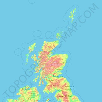
Name: Scotland topographic map, elevation, terrain.
Location: Scotland, United Kingdom (54.43398 -14.01552 61.06100 -0.32092)
Average elevation: 36 m
Minimum elevation: 0 m
Maximum elevation: 1,259 m
Make a donation
Other topographic maps
Click on a map to view its topography, its elevation and its terrain.
Make a donation
Make a donation
Wakebridge
United Kingdom > England > Derbyshire > Amber Valley > Crich Carr > Wakebridge
Average elevation: 181 m
Make a donation