Geolocate

Chapa topographic map

Interactive map

Click on the map to display elevation.

About this map

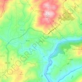
Name: Chapa topographic map, elevation, terrain.

Location: Chapa, Amarante, Porto, 4600-620, Portugal (41.29873 -8.07334 41.33873 -8.03334)

Average elevation: 210 m

Minimum elevation: 68 m

Maximum elevation: 424 m

Other topographic maps

Click on a map to view its topography, its elevation and its terrain.

Fregim

Portugal > Porto > Amarante

Average elevation: 277 m

Cepelos

Portugal > Porto > Amarante

Average elevation: 176 m

Padronelo

Portugal > Porto > Amarante

Average elevation: 240 m

Gondar

Portugal > Porto > Amarante

Average elevation: 298 m

Telões

Portugal > Porto > Amarante

Average elevation: 277 m

Lomba

Portugal > Porto > Amarante

Average elevation: 238 m

Candemil

Portugal > Porto > Amarante

Average elevation: 636 m

Carvalho de Rei

Portugal > Porto > Amarante

Average elevation: 646 m

São Gonçalo

Portugal > Porto > Amarante

Average elevation: 144 m

Bustelo

Portugal > Porto > Amarante

Average elevation: 575 m