
Thank you for supporting this site ❤️
Make a donation
Make a donation
Les Troncs topographic map
Click on the map to display elevation.
Thank you for supporting this site ❤️
Make a donation
Make a donation
About this map
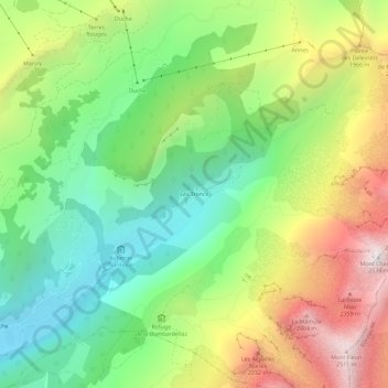
Name: Les Troncs topographic map, elevation, terrain.
Average elevation: 1,635 m
Minimum elevation: 1,047 m
Maximum elevation: 2,513 m
Thank you for supporting this site ❤️
Make a donation
Make a donation
Other topographic maps
Click on a map to view its topography, its elevation and its terrain.
Auberge Nordique
France > Auvergne-Rhône-Alpes > Haute-Savoie > Le Grand-Bornand > Les Troncs
Average elevation: 1,403 m