Geolocate

Tashkent topographic map

Interactive map

Click on the map to display elevation.

About this map

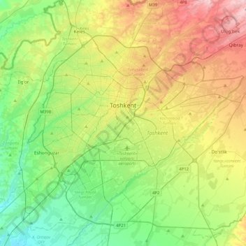
Name: Tashkent topographic map, elevation, terrain.

Location: Tashkent, 100000, Uzbekistan (41.16342 69.12171 41.39864 69.47697)

Average elevation: 438 m

Minimum elevation: 357 m

Maximum elevation: 571 m

Other topographic maps

Click on a map to view its topography, its elevation and its terrain.

Beshtut

Uzbekistan > Tashkent Region > Beshtut

Beshtut, Bostanlik district, Tashkent Region, Uzbekistan

Average elevation: 895 m

Amu Darya

Uzbekistan > Republic of Karakalpakstan

Amu Darya, Xo'jayli Tumani, Republic of Karakalpakstan, 230122, Uzbekistan

Average elevation: 75 m

Olmaty

Uzbekistan > Qashqadaryo Region > Olmaty

Olmaty, Shakhrisabz District, Qashqadaryo Region, 181300, Uzbekistan

Average elevation: 1,588 m

Akmola

Uzbekistan > Tashkent Region > Yukorichirchik district

Akmola, Yukorichirchik district, Tashkent Region, Uzbekistan

Average elevation: 456 m