
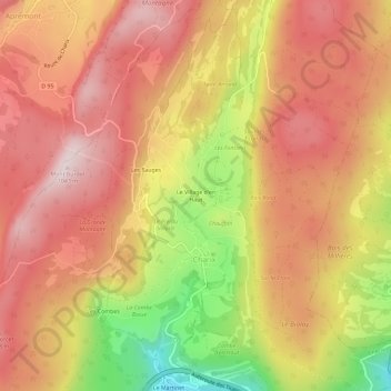
Le Village d'en Haut topographic map
Interactive map
Click on the map to display elevation.
About this map
Name: Le Village d'en Haut topographic map, elevation, terrain.
Average elevation: 884 m
Minimum elevation: 608 m
Maximum elevation: 1,050 m
Other topographic maps
Click on a map to view its topography, its elevation and its terrain.
Les Combes
France > Auvergne-Rhône-Alpes > Ain > Charix
Les Combes, Charix, Nantua, Ain, Auvergne-Rhône-Alpes, France métropolitaine, 01130, France
Average elevation: 837 m
Lac Genin
France > Auvergne-Rhône-Alpes > Ain > Charix
Lac Genin, Oyonnax, Charix, Nantua, Ain, Auvergne-Rhône-Alpes, France métropolitaine, 01130, France
Average elevation: 908 m